The Malacca Dilemma, the Bay of Bengal and India’s Campbell Bay Imperative
For decades, China’s greatest maritime anxiety has had a name: Malacca. Today, Beijing is quietly building geography around that vulnerability—from Kyaukpyu on Myanmar’s coast to the waters surrounding the Andamans. The contest, however, is no longer only about who controls the sea lanes. It is increasingly about who can see, sense and operate beneath them.
For India, this geography presents a warning and an opportunity. The same waters through which the Dragon seeks strategic depth place the Andaman and Nicobar Islands astride one of the world’s most consequential maritime approaches. At their Southern tip lies Campbell Bay—potentially not merely a military outpost, but India’s Eastern maritime nerve centre.
The Dragon Beneath the Surface
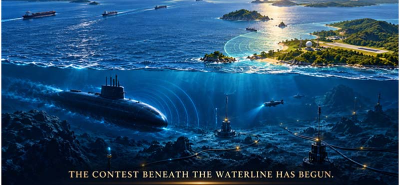
Maritime power is changing. China’s naval expansion is visible in carriers, destroyers and long-range deployments, but the less visible transformation is equally consequential. Submarines, unmanned underwater vehicles, seabed surveillance, oceanographic mapping, acoustic intelligence and undersea infrastructure are creating a battlespace where concealment can be as valuable as firepower. The Indian Ocean is becoming a contested information environment.
China’s strategic challenge is straightforward: its economy depends heavily on maritime trade and energy flows, while its principal routes pass through narrow and potentially vulnerable chokepoints. The response has been diversification—overland corridors, ports, pipelines, partnerships and a navy capable of operating farther from home. The Bay of Bengal sits directly within this effort.
The critical question for India is whether it will possess sufficient awareness, infrastructure and undersea capability to understand that presence before a crisis makes the difference consequential.
Escaping The Malacca Dilemma: The Dragon’s Bay Of Bengal Arc
The Malacca Dilemma describes China’s vulnerability to dependence on the Strait of Malacca for vital maritime commerce and energy. Kyaukpyu offers Beijing a partial workaround. Chinese-linked infrastructure at Myanmar’s Bay of Bengal coast includes a deep-water port project and oil and gas pipelines running towards Yunnan, providing an alternative route for some energy flows and connecting Southwestern China more directly with the Indian Ocean. Kyaukpyu does not abolish Malacca’s importance; its value lies in diversification. Political instability in Myanmar also complicates the corridor’s reliability.
- Kyaukpyu: The Strategic Back Door. Kyaukpyu is therefore best understood as a strategic enabler rather than a Chinese naval base by default. Its significance lies in the convergence of port infrastructure, energy connectivity and the China–Myanmar Economic Corridor. The project gives Beijing an Indian Ocean outlet without requiring every energy cargo to traverse Malacca. It also demonstrates how commercial infrastructure can create strategic options without declared military access.
For India, the implication is not that every Chinese-financed port should be treated as a future naval facility. The more important task is to monitor how commercial access, logistics, communications and security relationships evolve over time.
- Coco Islands: The Watchtower Question. The Coco Islands demand similar analytical discipline. Great Coco lies only about 55 kilometres North of India’s Andaman and Nicobar Islands. Reports have long alleged a Chinese signals-intelligence presence, but credible assessments found little evidence for a permanent Chinese intelligence base. What has changed is the observable development of Myanmar’s own facilities: satellite imagery has shown runway extension, hangars, a causeway and radar-related infrastructure, raising concerns about growing maritime surveillance capacity.
That distinction matters. India should neither dismiss the islands nor convert every Myanmar activity into evidence of Chinese control. Their strategic significance arises from geography itself. A strengthened surveillance facility there could observe maritime movements around the Northern approaches to the Andamans, regardless of who ultimately supplies equipment or expertise.
- Chattogram: Connectivity on the Eastern Flank. Chattogram adds another layer to the Bay of Bengal equation. Bangladesh’s principal maritime gateway is commercially important in its own right, while China and Bangladesh have expanded cooperation in infrastructure, ports, transport and maritime affairs. The two governments have also identified cooperation around Chattogram projects and maritime activity.
Chattogram should not be equated with Kyaukpyu, nor should economic engagement be interpreted automatically as military access. Its significance is networked. Ports, corridors, energy infrastructure and maritime partnerships can reshape regional connectivity. The lesson is that influence can emerge from the density of connections among nodes.
The Bay of Bengal: India’s Strategic Theatre
The Bay of Bengal is consequently becoming an integrated strategic theatre linking the Indian Ocean with Southeast Asia. Its importance derives from chokepoints, shipping routes, island geography and the concentration of critical infrastructure. The Andaman and Nicobar chain sits across this geography like a natural observation bridge between the eastern Indian Ocean and the approaches to Malacca.
India possesses an advantage China cannot manufacture: geography. But geography becomes strategic power only when connected by infrastructure, sensors, air power, maritime forces, logistics and sustained political attention.
- Campbell Bay: India’s Strategic Fulcrum. Campbell Bay on Great Nicobar is the logical Southern fulcrum of this architecture. INS Baaz, commissioned as the Southernmost Indian naval air station, was explicitly described by the Navy as overlooking the Strait of Malacca and dominating the Six Degree Channel. It already supports surveillance of the Southern Bay of Bengal, Malacca approaches and the Southern Indian Ocean.
The opportunity is to move from a forward operating location to a strategic hub. Campbell Bay can integrate air operations, maritime surveillance, logistics, naval support and undersea awareness while complementing the wider Andaman and Nicobar Command.
- Why Campbell Bay Cannot Wait. Accelerated development rests on strategic time. Infrastructure takes years to plan, approve, construct and operationalise, while maritime competition can change within months.
The Great Nicobar Project already recognises the island’s strategic and economic potential. The government describes it as a strategic maritime and economic hub, with a major trans-shipment terminal, international airport, power infrastructure and township. Its location, roughly 40 nautical miles from the East–West shipping route, gives it an important strategic advantage.
The defence component should proceed with urgency, alongside environmental safeguards and protection of indigenous communities.
- From Maritime Domain Awareness to Undersea Domain Awareness. India’s next conceptual leap must be from Maritime Domain Awareness to Undersea Domain Awareness. Knowing which ships are present is no longer sufficient. India must increasingly know what is moving below them, what sensors are operating on the seabed, where unmanned underwater systems may be deployed, and whether critical undersea infrastructure is being surveyed or interfered with.
That requires a fused architecture of satellites, aircraft, surface vessels, submarines, acoustic arrays, seabed sensors, unmanned underwater vehicles and artificial intelligence. Campbell Bay can become an important node in this network, linking information from the Andaman Sea, the Bay of Bengal and the approaches to Malacca.
- The Six-Degree and Ten-Degree Imperative. The islands’ geography should be treated as an operational system. The Six Degree Channel near Great Nicobar and the Ten Degree Channel farther North are not simply lines on a chart; they form maritime passages through a strategically positioned island chain. Their surveillance value increases when combined with airfields, naval facilities, sensors and rapid-reaction forces.
The objective should be persistent awareness: to know, classify and respond where necessary.
Campbell Bay: Military Station to Strategic Hub
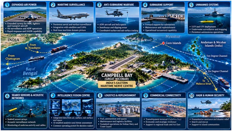
Campbell Bay now needs a clearly defined strategic architecture.
- The airfield should be expanded and equipped for sustained operations by appropriate surveillance, transport and combat-support aircraft.
- Maritime surveillance should become persistent rather than episodic, supported by long-range aircraft, unmanned systems and satellite inputs.
- Anti-submarine warfare capability must be strengthened through aircraft, helicopters, surface platforms and autonomous underwater systems.
- Submarine-support infrastructure should be developed so that the island can sustain, rather than merely observe, undersea operations.
- Seabed acoustic and sensor networks should be integrated into a regional picture.
- A permanent intelligence-fusion centre should combine naval, air, satellite, coastal and underwater information.
- Logistics, maintenance, fuel and replenishment facilities must support prolonged operations.
- Commercial infrastructure should reinforce strategic resilience rather than exist separately from it. The Galathea Bay transshipment project is particularly relevant because the government envisages Great Nicobar as a major maritime and economic hub.
- Communications must be hardened and redundant.
- The island’s military infrastructure should also support humanitarian assistance, disaster relief, search and rescue and evacuation.
The result would be a civil-military maritime hub whose utility derives from integration alone.
The Undersea Contest: India must See what the Dragon cannot Hide
The undersea domain will increasingly determine whether maritime awareness is real. Submarines remain central, but the future will involve networks of relatively inexpensive autonomous systems, seabed sensors and acoustic technologies capable of persistent observation. Commercial infrastructure adds another dimension. Undersea cables carry enormous volumes of global data, while ports, pipelines and offshore installations depend on vulnerable subsea networks.
This creates a new form of strategic competition in which the first move may be sensing rather than striking. Mapping the seabed, understanding acoustic conditions, identifying infrastructure and monitoring unusual activity can provide an advantage long before conventional hostilities begin.
India therefore needs an undersea strategy that joins the Navy, Coast Guard, scientific institutions, industry, intelligence agencies and technology organisations. Indigenous acoustic technology, autonomous systems, oceanographic research and secure data fusion deserve sustained investment. Partnerships with friendly Indo-Pacific countries can add complementary sensors, information and operating experience.
Resilience matters as much as deterrence: detecting threats, protecting infrastructure and sustaining communications when the undersea environment becomes contested.
The Dragon can be Watched
China’s effort to reduce the strategic consequences of the Malacca Dilemma is creating a wider geography of connectivity across the Bay of Bengal. Kyaukpyu provides an alternative Indian Ocean outlet; the Coco Islands raise surveillance questions because of their location and developing infrastructure; Chattogram illustrates how commercial and maritime networks can deepen regional connectivity. None should be simplistically labelled Chinese military bases. Their significance lies in cumulative possibilities created by geography, infrastructure and access.
India’s answer lies in exploiting its geographical advantage. The Andaman and Nicobar Islands are forward strategic assets between the Indian Ocean and Southeast Asia. Great Nicobar, and particularly Campbell Bay, can become the hinge between India’s continental economy, its maritime power and its Act East engagement.
The imperative is clear: accelerate Campbell Bay as an integrated strategic hub, strengthen island infrastructure, and build persistent undersea awareness around it. This must be done with ecological responsibility and respect for indigenous communities, because strategic permanence requires environmental and social legitimacy.
The Dragon may be learning to move through the deep waters around India’s Eastern flank. India does not need to mirror China’s methods or seek confrontation. It needs something more enduring: the ability to see first, understand continuously, and respond decisively when required.
The contest beneath the waterline has begun. Campbell Bay is where geography becomes strategic power.
The Dragon may disappear beneath the waves; from Campbell Bay, India must ensure it is never beyond sight.
ABOUT THE AUTHOR

Lt Gen Rajeev Chaudhry (Retd) is a social observer and writes on contemporary national and international issues, strategic implications of infrastructure development towards national power, geo-moral dimension of international relations and leadership nuances in changing social construct.