NavIC is not meant to replace Global Positioning System globally, nor is it a one-for-one substitute. It is better understood as a sovereign, complementary navigation capability that gives India autonomy where it matters most.
GPS is controlled by the United States Space Force, and while it is freely available for civilian use, its military-grade precision and continuity are not guaranteed to foreign states in times of conflict.
NavIC ensures that India is not vulnerable to signal denial, degradation, or selective availability—a critical concern in any high-intensity conflict scenario. It is about control over timing and positioning infrastructure, which underpins modern warfare, financial systems, and critical infrastructure.
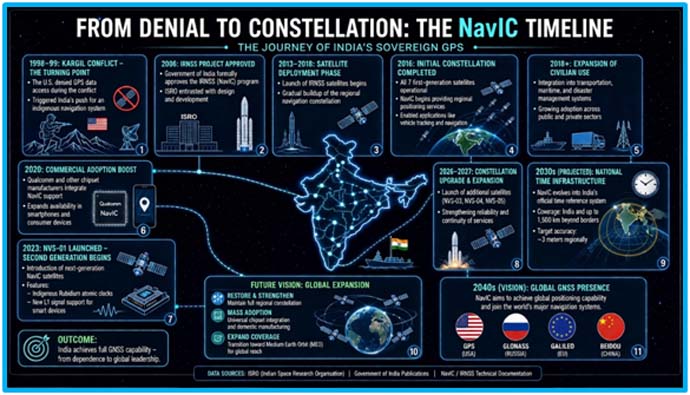
Every great national project has an origin story. NavIC’s begins not with triumph, but with humiliation. In the summer of 1999, high in the brutal, oxygen-starved heights of Kargil, Indian soldiers fought a war where geography was as much an enemy as the adversary sitting atop the ridgeline. Peaks towered above 16,000 feet. Visibility was unreliable. Each movement was a gamble. What the Indian military required most wasn’t just firepower—it was information. Precise, real-time positioning data that could mean the difference between a successful strike and a catastrophic miscalculation. The Indian Army had procured GPS technology from the United States just a year before the conflict, — yet when the moment of need arrived, the US, which controlled GPS, denied access to India. The United States used a technology called “selective availability” to degrade GPS accuracy to Indian armed forces, which hindered Indian operations. Soldiers were effectively fighting blind in the mountains while a working navigation system orbited overhead — a system India had paid for but did not control. That denial did more than complicate a battlefield—it exposed a vulnerability. In a world increasingly run on invisible signals from space, India realized something fundamental: sovereignty didn’t stop at land or sea. It extended upward, into orbit. That single act of denial planted the seed of NavIC — India’s own navigation system, to be built not just for convenience, but for independence.
What NavIC Actually Is
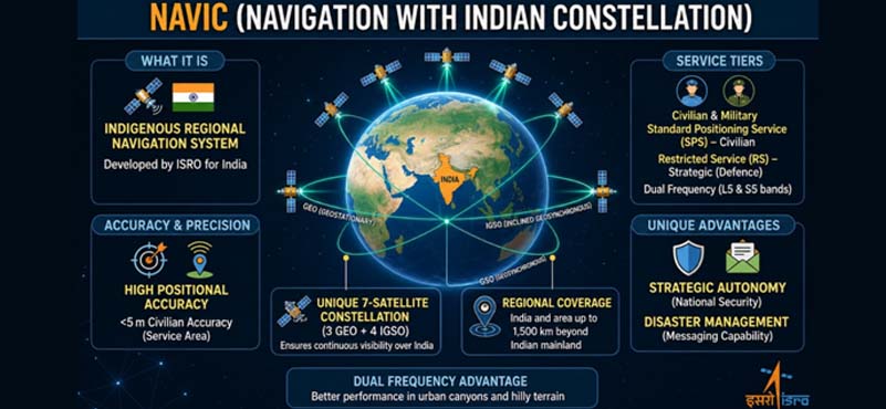
NavIC — short for Navigation with Indian Constellation — is also the Sanskrit word for sailor or navigator. The name carries its own quiet poetry. NavIC covers India and a region extending 1,500 km around it, with position accuracy of about 5 to 10 metres throughout the Indian landmass and about 20 metres in the Indian Ocean and surrounding region. For context, that covers the entire subcontinent, the Arabian Sea, the Bay of Bengal, and stretches deep into the Indian Ocean — the very waters where India’s strategic interests are most concentrated. The government gave approval for the NavIC project in 2006, and ISRO was entrusted with the task of building the system. The lesson was not lost on anyone: in the language of geopolitics, access to technology is not the same as ownership of it.
NavIC offers two levels of service: a Standard Positioning Service open for civilian use, and a Restricted Service, an encrypted channel for authorised users including the military. This dual architecture is deliberate — it ensures that even if the civilian signal were somehow compromised or interfered with, India’s defence forces have a sovereign, encrypted fallback.
NavIC is fully under the control of the Government of India and does not depend on other systems for providing position service within its service region. That sentence, simple as it reads, is the entire point.
Rethinking Navigation: The Power of Staying Regional
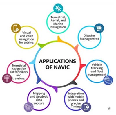
Navigation is not just about getting from point A to point B. It is the invisible backbone of modern civilisation. Timing signals from navigation satellites synchronise financial transactions, power grids, telecom networks, and air traffic control. Positioning data guides disaster relief, tracks fishing fleets, monitors railways, and directs precision agriculture. The nation that controls this infrastructure — even quietly, from orbit — holds enormous leverage.
At first glance, NavIC might seem modest compared to global giants like GPS. It doesn’t blanket the entire planet. It doesn’t rely on sprawling constellations of dozens of satellites. And that’s exactly the point. NavIC is designed as a regional specialist, not a global generalist. Its mission is simple: deliver exceptionally accurate positioning over India and its surrounding region. Instead of spreading resources thin, NavIC concentrates them.
Its architecture is elegant. A compact constellation of satellites sits in geostationary and geosynchronous orbits, effectively “hovering” over the Indian subcontinent. Unlike GPS satellites that constantly move across the sky, NavIC satellites remain fixed relative to the ground. The result? Signals that drop almost vertically. In dense urban jungles or deep Himalayan valleys—places where traditional GPS signals struggle—NavIC cuts through with surprising reliability. Add to that its dual-frequency design, which corrects atmospheric distortions in real time, and you get positioning accuracy that rivals, and sometimes exceeds, global systems within its domain. This is not a compromise. It’s a strategy.
The Space Race You Don’t See
Navigation systems are more than technological tools—they are instruments of geopolitical power. The world of sovereign navigation systems is an extraordinarily exclusive one. The United States operates GPS with 31 satellites, regarded the global gold standard. Russia maintains GLONASS with 24 satellites. Europe built Galileo with 26 to ensure autonomy. China’s BeiDou has rapidly expanded into a global network with 35 satellites, doubling as a tool of strategic influence across developing regions. Each system reflects a nation’s priorities—and its ambitions. Every one of these systems was built at enormous cost, over decades, for precisely the same reason India built NavIC, because no great power trusts another great power with its eyes.
India now sits in that company however it chose a different path. Rather than competing for global dominance, it focused on strategic sufficiency, control what matters most and do it completely. NavIC is not about covering oceans far away—it’s about securing India’s digital backyard.
The Crisis: When Time Stopped
If satellites are the body of a navigation system, atomic clocks are its heartbeat. Every position calculated by NavIC — or any similar navigation system—is based on time. Satellites broadcast signals with exact timestamps. Your device calculates how long those signals took to arrive and translates that into distance. But here’s the catch: even a billionth of a second error can throw your location off by tens of centimetres. That’s why these systems rely on atomic clocks—devices so precise they lose only a second over millions of years. And that’s where things went wrong. The first generation of NavIC satellites used imported atomic clocks. Over time, these began to fail —quietly at first, then alarmingly. The situation escalated in March 2026, when the last functioning clock on a key satellite stopped working. It wasn’t just a technical glitch. It was a systemic shock. With fewer operational satellites, NavIC’s coverage weakened. The system edged toward a critical threshold where reliable positioning could no longer be always guaranteed.
The Invisible Risks of a “Blind Spot”
When a navigation system falters, the consequences aren’t always visible—but they are profound. One major concern is signal spoofing—where false navigation data is fed into systems, potentially misleading aircraft, ships, or even military operations. Without a reliable indigenous system, India risks depending on foreign signals it cannot fully verify. At the same time, China’s BeiDou system has been steadily expanding its footprint across South Asia, offering advanced capabilities—including satellite messaging—that extend beyond navigation. In the absence of a strong NavIC presence, influence follows infrastructure.
Crisis Leads to Capability
If the failure exposed a weakness, it also triggered a transformation. India had already begun working on its own atomic clocks—one of the most complex technologies in modern engineering. Now, that effort became urgent. The result – indigenous atomic clocks, developed and space-qualified within India. These new systems debuted with the next generation of NavIC satellites, marking a quiet but profound shift. India was no longer just operating a navigation system—it was mastering the technologies that sustain it. The upcoming satellites in the NVS series are more resilient, longer-lasting, and fully equipped with Indian-built components. In space, self-reliance is not a slogan. It’s survival.
Challenges Persist
Sovereignty, like any ambitious project, comes with setbacks. NavIC’s story is not without its own turbulence and acknowledging that honesty is what makes the argument credible. Out of the 11 navigation satellites launched by India so far, only three — IRNSS-1B, IRNSS-1I, and NVS-01 — are currently able to provide position, navigation, and timing services, and even these operate with inconsistent reliability. Several of the first-generation satellites suffered atomic clock failures. India may need another 15 to 18 months to partially revive its struggling NavIC system, with replacement satellites NVS-03, NVS-04, and NVS-05 expected to be launched within that window.
These are real limitations. A system with three functional satellites cannot yet claim to be the full operational alternative to GPS. But consider what the setbacks reveal. The first-generation satellites used foreign-origin rubidium atomic clocks sourced from Israel. When those clocks failed, India was reminded — again — of the cost of dependence. The response? ISRO developed indigenous Indian rubidium atomic clocks to reduce dependence on imported frequency standards. These clocks will power the next generation of NavIC satellites. The wound India suffered became a workshop. The NVS series represents a major technological step forward, particularly with the adoption of indigenous atomic clocks. These domestically developed systems have shown greater reliability than earlier imported versions and support India’s broader Make in India initiative. The arc of NavIC is not a straight line upward. It bends, corrects, and climbs again — which is exactly what sovereign capability looks like when it is being built from scratch.
The Larger Picture: Data as Power
 In the 21st century, the most consequential borders are not drawn on maps. They are written in code, encoded in frequencies, and transmitted from orbit. Who controls your navigation signal controls where you think you are. Who controls your timing signal controls when your systems believe transactions occur. Who controls your positioning data controls the patterns of your economy, your logistics, your military movement.
For most of recorded history, great powers projected influence through territory, trade, and force. Today, they also do it through infrastructure — quietly, continuously, invisibly. GPS was not just an American gift to the world. It was — and remains — an instrument of American situational awareness. BeiDou is China’s version of the same logic. Galileo is Europe insisting it will not depend on Washington or Moscow for something this fundamental. NavIC is India saying: we understand the game, and we are playing it.
A Constellation, A Commitment
The word NavIC was chosen carefully. A sailor navigates not by standing still, but by reading stars, correcting course, and pressing forward through uncertainty. India’s navigation system, with all its present limitations and future ambitions, embodies precisely that spirit. With the planned NavIC 2.0, India aims to graduate from a regional navigation system to a global one — with 12 additional satellites in medium earth orbit by 2028, potentially expanding to 24 or more by 2035.
The vision is clear even if the path remains difficult. A nation that once had GPS data denied to it in wartime is now building the infrastructure to ensure that never happens again — and in doing so, is quietly reordering its place in the hierarchy of technological power. NavIC’s journey has not been smooth. It has faced denial, disruption, and near failure. But that’s what makes it significant. From the lessons of Kargil to the atomic clock crisis of 2026, each challenge has pushed India closer to technological independence. Today, NavIC stands not just as an alternative to global systems, but as a statement of intent. In a world where control over data, timing, and positioning defines power, India is no longer navigating by someone else’s map. It is charting its own. As the new NVS satellites take their stations, they do so with an Indian heart and an Indian rhythm. India has secured the sovereign sky. As our Honourable Prime Minister Sh. Narendra Modi remarked when the system was first named –
“We now have a system that is for the common man… and ensures that India never has to depend on others for navigation.”
The blue dot on your screen isn’t just a coordinate anymore; it is a declaration of independence. NavIC is more than a constellation, it is our compass for sovereignty.
ABOUT THE AUTHOR
 Lt Gen Tarun Chawla, was commissioned into the Regiment of Artillery in Jun 1984. He has served with the United Nations Mission in Liberia and has been an instructor at the College of Defence Management at Secunderabad. The officer has commanded an Artillery Brigade in the LC Sector in J&K, and an Artillery Division as part of Army’s Western Command. He was the Director General Financial Planning, prior to assuming the role of Director General of Artillery.