The Geography of Possibility
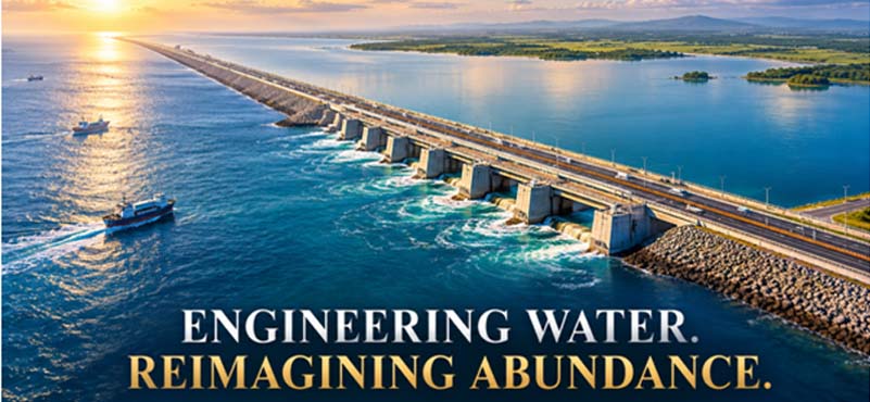
A vast expanse of seawater separates two parts of Gujarat, while the land beyond its shores continues to grapple with the challenge of dependable freshwater. This geographical paradox lies at the heart of the Kalpasar Project, one of India’s most ambitious proposals to integrate water security, transport connectivity, renewable energy and regional development within a single infrastructure system. Conceived around the Gulf of Khambhat, the project seeks to transform a natural geographical divide into an instrument of economic opportunity.
For Saurashtra, where water availability has long influenced agriculture, livelihoods and industrial development, the prospect of a large coastal freshwater reservoir carries profound implications. Kalpasar proposes to capture and store freshwater through a barrier across the gulf, while also creating a transport corridor linking Saurashtra with South Gujarat. Its significance, therefore, extends beyond the construction of a dam. It raises a larger question about India’s capacity to use engineering to overcome geographical constraints while remaining sensitive to the natural systems on which development ultimately depends.
A Vision takes Shape
Kalpasar, derived from the Gujarati expression Kalpavriksha Sagar, evokes the idea of a sea capable of fulfilling aspirations. The proposal has evolved over decades from a water-resource concept into a multipurpose development project incorporating freshwater storage, transport infrastructure and renewable energy. Its central objective remains the augmentation of freshwater availability in water-stressed parts of Gujarat, particularly Saurashtra, alongside improved connectivity with the state’s industrial and commercial centres.
The project’s long gestation reflects the complexity of intervening in a dynamic marine environment. Hydrological investigations, geotechnical surveys, hydraulic modelling, wave studies and assessments of environmental consequences are indispensable to determining whether such an undertaking can be executed safely and economically. The proposed arrangement also requires coordination among water-resource authorities, transport planners, energy agencies and environmental regulators.
In a written reply to the Rajya Sabha on 27 July 2026, the Ministry of Jal Shakti reported that the Detailed Project Report (DPR) was at an advanced stage of finalisation. The government also identified Indo-Dutch technical cooperation as an avenue for strengthening the design through expertise in coastal engineering, salinity management, hydraulic modelling and climate resilience. This is an important milestone, but it must not be confused with final construction approval or the completion of statutory clearances. Kalpasar has reached a stage where its extraordinary ambition must be translated into a technically validated and financially credible execution plan.
Engineering the Gulf
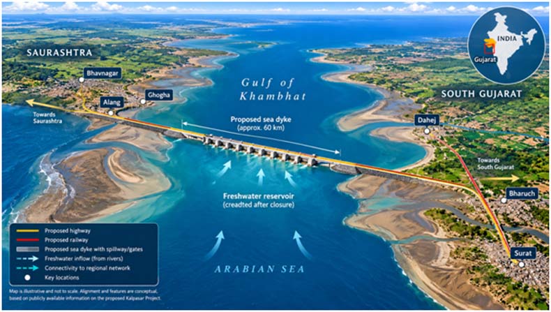
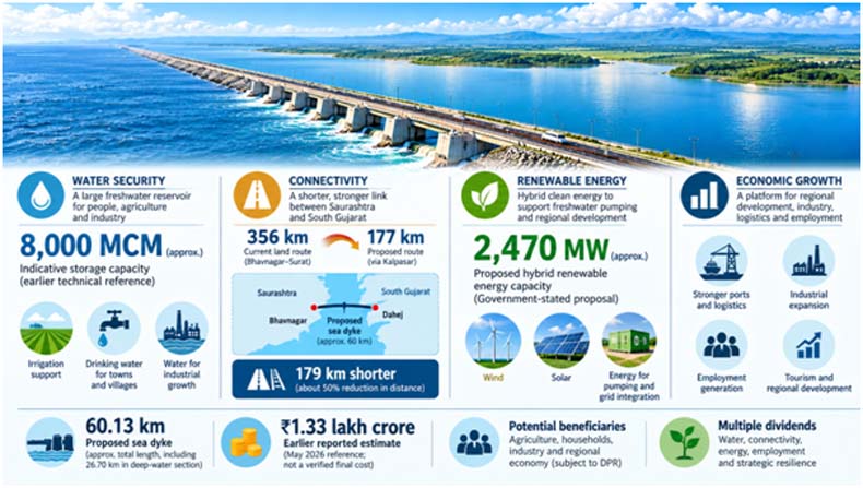
The defining engineering challenge is the proposed construction of a sea dyke across the Gulf of Khambhat. A technical memorandum submitted to India’s Central Water and Power Research Station describes a reference alignment approximately 60.13 kilometres long, including around 26.70 kilometres across the deeper gulf and extensions along the adjoining shallower sections. These dimensions illustrate the physical scale of the undertaking, although the latest DPR must establish the final configuration.
Building such a structure requires much more than placing earth, rock and concrete across a waterway. The foundations must be designed for the actual seabed conditions, while the dyke must withstand waves, currents, tidal forces and potentially severe storm events. Spillways, gates and flood regulators would need to manage water levels and discharge without compromising structural stability. Protection against erosion, seepage, saline intrusion and sediment accumulation would be integral to long-term performance.
The Gulf of Khambhat presents particularly demanding hydraulic conditions because of its substantial tidal variations and strong currents. Physical model experiments and mathematical simulations are essential to understanding how the proposed barrier might change tidal propagation, wave behaviour, sediment movement and water circulation. The design must also account for seismic considerations, extreme rainfall, river floods and the possibility that climate change could alter future coastal hazards.
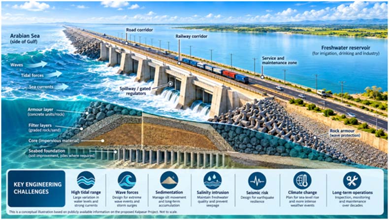
The proposed transport corridor introduces another layer of engineering complexity. Road and rail infrastructure must coexist with the hydraulic structures, accommodate maintenance requirements and remain resilient under demanding environmental conditions. Instrumentation, structural monitoring and carefully planned inspection regimes would be necessary throughout the project’s operating life.
The real engineering achievement would not simply be the completion of a barrier across the gulf. It would be the creation of a dependable system in which coastal protection, freshwater storage, hydraulic regulation and transport infrastructure function together safely over several decades.
The Water Dividend
Freshwater security is the principal justification for Kalpasar, and the project’s economic case must ultimately be measured against the quantity and reliability of water it can deliver. The Central Water and Power Research Station has published earlier material describing storage concepts of approximately 10,000 million cubic metres, while other project documents have used different configurations and estimates. Such figures should not be treated as interchangeable: the final DPR must clarify gross storage, usable storage and dependable annual water yield.
For agriculture, a reliable supply could reduce exposure to rainfall variability, stabilise production and support higher-value crops where soil and market conditions permit. Greater water security could also benefit villages and towns, while dependable supplies could support industrial activity in a state whose manufacturing ambitions place increasing demands on natural resources. The resulting gains might extend to rural employment, household security and investment in areas where water scarcity constrains economic opportunities.
Yet the availability of storage does not automatically translate into dependable supply. The volume of freshwater entering the reservoir, seasonal inflows, competing demands, evaporation, water quality and conveyance losses will determine how much water can actually be delivered. The proposed system must also demonstrate that freshwater can be maintained in a basin connected to a saline marine environment and that pumping, treatment and distribution costs remain manageable.
Water allocation will require careful planning to balance drinking-water needs, agriculture, industry and ecological requirements. Kalpasar’s success will therefore depend not merely on how much water it can hold, but on whether that water can be delivered affordably, equitably and reliably when communities and productive sectors need it most.
Reconnecting the Economy
Kalpasar’s most distinctive feature is its attempt to combine water infrastructure with transport and energy development. The proposed highway-cum-rail corridor could substantially change the economic relationship between Saurashtra and South Gujarat, making the project a potential catalyst for regional integration rather than an isolated water-resource intervention.
According to the Ministry of Jal Shakti’s July 2026 statement, the proposed alignment could reduce the Bhavnagar–Surat land-route distance from approximately 356 kilometres to 177 kilometres, a reduction of 179 kilometres, or about 50 per cent. This could improve access to markets, facilitate freight movement and strengthen connections between industrial centres, ports and their hinterlands. Actual savings in travel time and logistics costs, however, would depend on the final alignment, operating conditions and the quality of connecting infrastructure.
The energy component is equally significant. The government has envisaged approximately 2,470 megawatts of hybrid renewable-energy capacity on reclaimed land that is presently submerged during high tide. The proposed generation is intended, among other uses, to support freshwater pumping for irrigation. This creates the possibility of integrating renewable energy with water management, although installed capacity alone cannot establish annual electricity production or demonstrate that pumping will be economical. The technology mix, generation profile, grid connection and seasonal demand must be assessed in the DPR.
Together, these components could support industrial expansion, warehousing, logistics, tourism and new employment opportunities. Better connectivity could reinforce the benefits of more dependable water supplies, while industrial growth could increase the economic value generated by improved infrastructure. These outcomes will not arise automatically; they require viable feeder networks, effective land-use planning, commercially sound investments and coordinated development beyond the project boundary.
The Human Dividend and Strategic Resilience
The ultimate purpose of infrastructure is to improve people’s lives, and Kalpasar must be evaluated against that standard as much as against its engineering specifications. More dependable water, improved connectivity and new economic activity could strengthen rural livelihoods, create construction and service-sector employment, improve access to markets and encourage investment in less-connected areas. The lasting social dividend, however, will depend on whether temporary construction activity develops into sustainable employment and broadly distributed prosperity.
The project could also contribute to India’s strategic resilience through its civilian infrastructure. Water security can reduce the vulnerability of communities and industries to drought, while an additional transport connection can diversify routes and strengthen economic continuity. More resilient supply chains and a stronger regional industrial base could support the wider economic capacity on which national security ultimately rests.
These are meaningful strategic benefits, but they should not be exaggerated into claims that Kalpasar would directly transform the military balance or automatically become a defence corridor. Its strategic significance would emerge primarily from the dependable civilian systems it could support.
Equally important is the position of communities whose existing livelihoods might be affected. Fishing communities, salt-pan workers and coastal settlements must have a meaningful place in project planning, impact assessment and compensation arrangements. A project that improves regional prosperity while imposing unaddressed costs on vulnerable groups would fall short of its developmental promise. The social test is whether the benefits are shared fairly and whether those most exposed to disruption receive adequate protection.
The Environmental and Fiscal Reckoning
The Gulf of Khambhat is a living coastal system, not an empty space awaiting engineering intervention. Altering its tidal circulation could influence sediment transport, salinity, coastal morphology, fisheries, mangroves and estuarine habitats. Earlier environmental appraisal records have raised concerns relating to fisheries, erosion, sedimentation, water quality and impacts on mangroves and Aliabet Island. These issues demand rigorous investigation, rather than assumptions that mitigation measures will necessarily eliminate adverse consequences.
The environmental assessment must examine cumulative impacts alongside the effects of the dyke itself, including interactions with existing industrial and coastal infrastructure. It should address ecological flows, fish migration, flood discharge, potential changes to adjoining shorelines, construction impacts and long-term monitoring. Independent scientific scrutiny and transparent public consultation are essential because ecological changes could extend beyond the immediate construction footprint.
The fiscal challenge is no less consequential. A 2022 environmental-clearance application cited an estimated project cost of ₹1,00,200 crore, while a fresh application reported in May 2026 referred to approximately ₹1,33,246 crore. These are estimates from different stages of project development, not necessarily directly comparable final costs. The latest DPR must establish the current estimate and explain changes in scope, prices and component costs.
A credible economic appraisal must include construction, financing, operation and maintenance, pumping, rehabilitation and environmental mitigation. It must also test whether projected benefits remain attractive under scenarios involving cost overruns, construction delays, lower freshwater availability and additional ecological safeguards. The project deserves serious consideration precisely because its scale makes fiscal discipline indispensable.
From Ambition to Action
Kalpasar represents an ambitious attempt to integrate water security, transport connectivity, renewable energy and regional economic development within a single infrastructure vision. Its potential is substantial, but realising it requires a disciplined sequence of decisions rather than faith in engineering ambition alone.
The immediate priority must be a technically validated DPR supported by dependable hydrological estimates, robust coastal engineering, credible energy calculations and a transparent assessment of lifecycle costs. Environmental and social safeguards must be incorporated into the design from the outset, while independent scrutiny should test the assumptions underlying projected benefits. Clear institutional responsibility for construction, water allocation, energy, transport and long-term maintenance will be equally important.
Implementation should proceed through evidence-based decision gates, with major financial commitments linked to verified feasibility, statutory approvals and realistic delivery plans. This approach would not diminish the project’s ambition; it would protect that ambition from avoidable technical, financial and ecological failures.
Kalpasar’s wider lesson is that integrated infrastructure can potentially create value far beyond the sum of its individual components, provided that the components are genuinely compatible and their costs are honestly assessed. The project offers Gujarat an opportunity to reconsider the relationship between its geography and its development, but the promise must be established through science, economics and responsible governance.
The true measure of Kalpasar will not be the length of the barrier across the Gulf of Khambhat, but the enduring value it creates on either side of it—in every drop of dependable water, every journey shortened, every livelihood strengthened and every generation better prepared for the future.
ABOUT THE AUTHOR
Lt Gen Rajeev Chaudhry (Retd) is a social observer and writes on contemporary national and international issues, strategic implications of infrastructure development towards national power, geo-moral dimension of international relations and leadership nuances in changing social construct.