
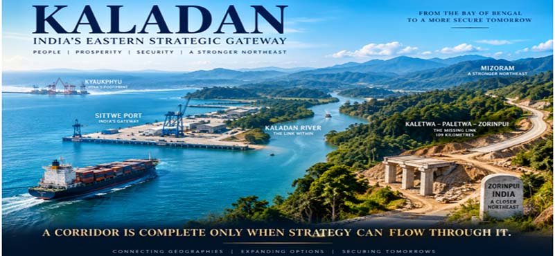
In geopolitics, alternative routes are not luxuries. They are insurance.
That proposition acquires fresh meaning in India’s Eastern neighbourhood. Bangladesh’s Prime Minister Tarique Rahman was unable to attend the 2026 BRICS summit in New Delhi, amid unresolved bilateral differences, while India and Bangladesh continue to work towards a future bilateral visit. At the same time, China’s infrastructure footprint around the Bay of Bengal continues to shape the strategic geography of Myanmar. Inside Myanmar, conflict has transformed the operating environment for every major cross-border connectivity project. For India, these developments reinforce an old strategic truth: access that depends upon a single corridor, a single neighbour or a single political assumption is inherently fragile.
It is against this backdrop that the Kaladan Multimodal Transit Transport Project (KMTTP) deserves to be viewed afresh. Conceived initially as an alternative connectivity route to India’s Northeast, Kaladan is no longer merely a transport project. It is potentially an instrument of strategic redundancy, a maritime gateway for the Northeast and an Indian node in the wider Bay of Bengal strategic geography.
The Corridor Beneath the Strategy
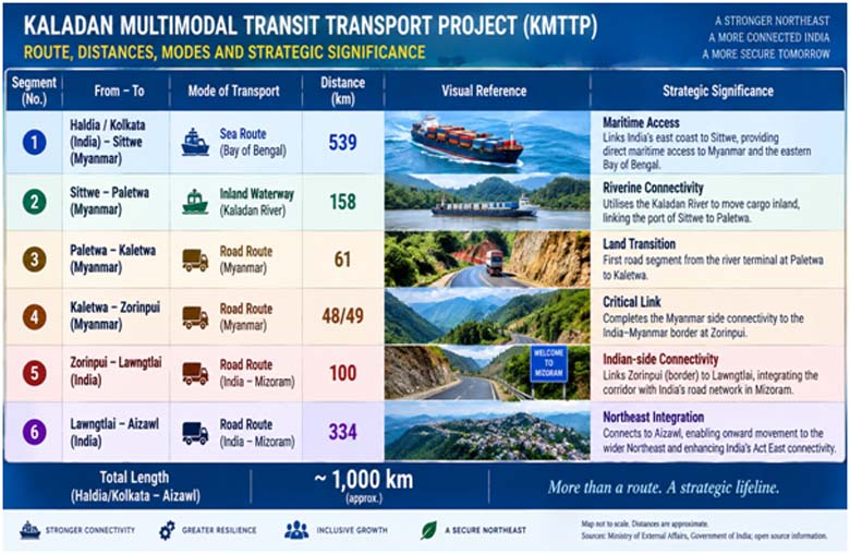
Kaladan is an unusually ambitious piece of infrastructure because it is not one road, one railway or one port. It is a chain of three modes of movement. Cargo can travel approximately 539 kilometres by sea from Haldia to Sittwe, move another 158 kilometres upstream along the Kaladan River to Paletwa, and then proceed by road for about 110 kilometres to the India–Myanmar border at Zorinpui. From there, roughly another 100 kilometres of road connects the corridor to India’s national highway network. The official design therefore creates a sea–river–road axis from India’s eastern seaboard into Mizoram and the wider Northeast.
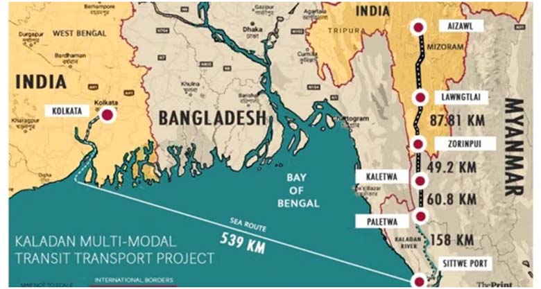
The engineering challenge is substantial. The road alignment crosses difficult hill terrain, dense vegetation, heavy monsoon country and numerous streams and river crossings. This was never an ordinary highway project. The original project itself evolved significantly: after early studies, the Cabinet approved it in 2008 at ₹535.91 crore; a revised cost estimate of ₹2,904.04 crore was approved in 2015. The scale of revision reflects the complexity of constructing and coordinating infrastructure across difficult terrain and another sovereign state.
Yet the strategic logic remained constant. The Government has explicitly described Kaladan as an alternative route to the Northeast and as a means of reducing pressure on the Siliguri Corridor. The project was therefore conceived not merely to save time or freight cost, but to create strategic choice.
Sittwe: From Port to Strategic Node
The inauguration of Sittwe Port in May 2023 marked a significant milestone. India Ports Global Limited has managed the port since April 2024, making Sittwe its second overseas port operation after Chabahar. The port and inland-waterway facilities establish the maritime end of a corridor that can potentially connect India’s Eastern coast with Mizoram without relying entirely on the terrestrial route through Siliguri.
That gives Sittwe a significance beyond commercial cargo. In Indian strategic discourse, the port is often discussed as part of the broader “Necklace of Diamonds” concept: a network of maritime access points, partnerships and strategic relationships intended to preserve India’s options across the Indian Ocean region. The phrase is not a formal Indian doctrine, but Sittwe fits the underlying logic of diversified maritime access.
Its importance becomes clearer when placed against the geography of China’s presence in Myanmar. Sittwe sits on the same wider Bay of Bengal coast where China has invested heavily in Kyaukphyu, including a deep-water port and the China–Myanmar Economic Corridor. It would be simplistic to portray Sittwe as a military counter to Kyaukphyu. Its more credible significance lies in providing India with operational maritime presence, logistical access and strategic visibility in a geography where Chinese infrastructure has acquired considerable weight.
Kyaukphyu and Sittwe: Two Strategic Geographies
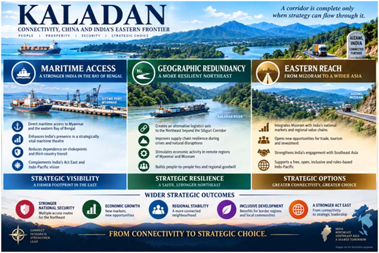
The contrast between the two projects is instructive. China’s Kyaukphyu architecture connects Myanmar’s Western seaboard with China’s Yunnan province and forms part of a larger economic and energy network. India’s Sittwe–Kaladan architecture points in the opposite strategic direction: from the Bay of Bengal towards India’s Northeast and, through the Act East framework, towards Southeast Asia.
One connects China to the Indian Ocean; the other can connect India’s Eastern seaboard to its own frontier.
That does not make them mirror images. Their scale, ownership structures, commercial models and strategic purposes differ. But geography matters. Ports, roads, pipelines and logistics facilities create options for states, and states with more options possess greater strategic resilience.
For India, therefore, Sittwe should be seen as an asset in a larger Eastern architecture comprising Kaladan, the India–Myanmar–Thailand Trilateral Highway, the Northeast Economic Corridor and India’s broader maritime engagement in the Bay of Bengal. The objective is not confrontation for its own sake. It is to ensure that India is not strategically absent from a neighbourhood in which other powers are steadily increasing their presence.
Siliguri and the Logic of Redundancy
The Siliguri Corridor remains indispensable. Kaladan cannot replace it, nor should it be presented as doing so. Its strategic value is different. It offers another axis.
A second artery is not built because the first is expected to fail; it is built because a nation cannot afford to have only one.
This principle is particularly relevant to the Northeast. Geography has historically imposed a structural vulnerability on the region. Multiple roads, waterways, airfields, rail links and cross-border corridors are gradually changing that equation. Kaladan adds a maritime dimension to this redundancy. In peacetime, it can diversify logistics and stimulate trade. In a crisis, its value could lie in preserving access and mobility when a conventional route becomes constrained.
The Delay: More Than a Construction Problem
Kaladan’s long gestation cannot be attributed to one cause. The project has had to overcome engineering, administrative, financial, diplomatic and security challenges simultaneously.
- First was the complexity of the physical task. Mountainous terrain, heavy rainfall, bridges, drainage and remote work sites impose a very different construction environment from conventional highways.
- Second was the evolution of the project itself. The original conception changed as technical studies and implementation requirements developed, contributing to substantial cost revision.
- Third was the challenge of executing major infrastructure on foreign territory. Land access, movement of equipment, local coordination, contractual arrangements and inter-governmental approvals inevitably introduce complications that do not arise in a domestic road project.
- The fourth and increasingly decisive factor has been Myanmar’s internal conflict. The political and security environment has changed dramatically since the project was conceived. The Kaladan corridor passes through areas where state authority is contested and where armed groups exercise substantial influence. Recent assessments note that the Sittwe–Paletwa–border geography is now embedded in this conflict environment.
This distinction matters. The early history of Kaladan was predominantly an infrastructure and implementation challenge. The contemporary challenge is increasingly geopolitical and security-related.
The 109-Kilometre Paradox
The paradox is striking. The waterway component was completed and inaugurated in May 2023. The Government’s latest update states that the remaining road component is a 109-kilometre, two-lane highway from Paletwa to Zorinpui.
The port exists. The river route exists. The strategic concept exists. But the corridor remains incomplete.
Those 109 kilometres are therefore not simply a final construction package. They are the hinge on which the value of the entire multimodal system turns. A port without reliable onward connectivity cannot deliver the strategic effect for which the corridor was conceived.
In multimodal infrastructure, the value of the whole is determined not by the length of the completed sections, but by the reliability of the missing link.
The Way Ahead: Make Kaladan a Strategic Mission
The first question should be whether India’s Border Roads Organisation can be brought into the unfinished road component. This deserves serious examination, not as a criticism of existing agencies but as a capability-based proposition.
- BRO has already demonstrated overseas execution under extreme conditions. Its 218-kilometre Zaranj–Delaram Highway in Afghanistan, completed in 2009, connected Delaram with Zaranj near the Iranian border and provided Afghanistan an alternative route towards Iran. India’s Ministry of Road Transport and Highways recorded that BRO completed the road despite prevailing insurgency and many operational difficulties. The Myanmar terrain and conflict environment are different, so the comparison cannot be simplistic. Yet the institutional question is compelling: if India possesses an organisation designed for strategic roads in difficult terrain and with demonstrated overseas experience, should a BRO-led or BRO-supported model be examined for the approximately 109-kilometre Kaletwa–Paletwa–Zorinpui link, subject to India–Myanmar arrangements?
- Second, Kaladan requires a permanent strategic coordination mechanism bringing together the Ministry of External Affairs, Ministry of Defence, road and shipping authorities, the Northeast Development Ministry and security agencies. A corridor crossing modes, ministries and a sovereign border cannot be managed as a conventional departmental project.
- Third, the 109 kilometres should be treated as strategic infrastructure. Mission-mode monitoring, clear milestones, contingency plans and high-level accountability are essential. Security must be designed into the construction model rather than addressed as an external variable.
- Fourth, resilience must extend beyond construction. Alternative logistics arrangements, local engagement, maintenance capacity, communications and contingency routes should be built into the corridor’s operating concept. A strategic corridor must be capable of absorbing disruption.
- Fifth, Sittwe should be commercially activated in parallel. Cargo generation, shipping schedules, warehousing, container handling and customs procedures should not wait for every component of the corridor to reach perfection. The objective should be to create an ecosystem ready to scale when the road becomes available.
- Sixth, India’s side must advance simultaneously. Zorinpui, Mizoram’s connecting roads, customs facilities, logistics parks, warehousing and onward national-highway connectivity must be synchronised with the Myanmar-side construction. Otherwise, one bottleneck will simply be replaced by another.
- Finally, Kaladan must be integrated into a larger Eastern strategic architecture. Sittwe, Kaladan, the Trilateral Highway, the Northeast Economic Corridor and India’s Bay of Bengal maritime strategy should be planned as interconnected elements rather than isolated projects. In strategic affairs, the route that remains available when circumstances change can matter more than the route that is cheapest when circumstances are stable.
From Connectivity to Strategic Choice
Kaladan was conceived in a different geopolitical era. Its importance has grown precisely because that era has changed. Bangladesh’s evolving strategic relationship with India, China’s expanding infrastructure presence around the Bay of Bengal, Myanmar’s internal conflict and the continuing importance of the Siliguri Corridor all underline the value of strategic alternatives.
The project should therefore be judged by more than kilometres constructed, rupees spent or tonnes of cargo moved. Its deeper value lies in strategic optionality. India does not need Kaladan because geography has become less difficult. It needs Kaladan because geography, geopolitics and security have become more intertwined.
The real value of Kaladan will not be measured by the cargo it carries in peacetime, but by the strategic options it preserves when geography, geopolitics and crisis converge.
ABOUT THE AUTHOR

Lt Gen Rajeev Chaudhry (Retd) is a social observer and writes on contemporary national and international issues, strategic implications of infrastructure development towards national power, geo-moral dimension of international relations and leadership nuances in changing social construct.