
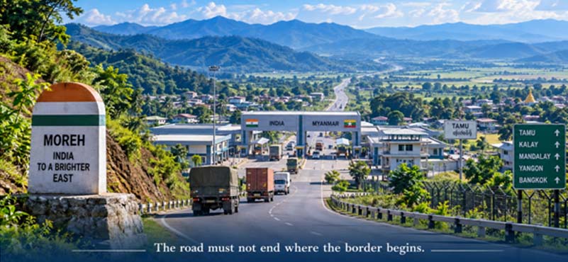
Where India Meets the East
There are places on a map that are important because of what they contain, and there are places that are important because of what they connect. Moreh belongs unmistakably to the second category. Perched on India’s border with Myanmar in Manipur, approximately 110 kilometres from Imphal, Moreh is not merely a frontier town or a customs point. It is India’s physical interface with Myanmar and, potentially, its land bridge to Southeast Asia. The Moreh–Tamu crossing lies on the proposed 1,360-kilometre India–Myanmar–Thailand Trilateral Highway, giving this otherwise remote border settlement an importance far greater than its size. The Land Ports Authority of India itself describes Moreh as India’s “Gateway to the East” and identifies the Moreh–Tamu route as the only feasible land route for trade between India and Myanmar and onward to Southeast Asia.
Yet there is a paradox at Moreh. India has spent years building the physical architecture of a gateway, but the strategic potential of that gateway remains only partially realised. An Integrated Check Post has been operational since 2018, modern land-port infrastructure has been created, road connectivity has improved and Moreh occupies a central place in India’s Act East vision. Yet the volume and regularity of cross-border movement have not matched the geography’s promise. Moreh therefore presents India with a larger strategic question: what does it take to convert a border crossing into a functioning strategic corridor?
India has built the gate at Moreh. The next challenge is to make the corridor beyond it work.
From Frontier Outpost to Strategic Gateway
Moreh’s transformation mirrors the evolution of India’s thinking about its Northeast. For decades, the region was viewed predominantly through the prism of distance, difficult terrain and security. The strategic imagination was largely inward-looking: connect the Northeast to the rest of India and secure the frontier. The Act East policy introduced a different proposition. The Northeast could become not India’s geographical extremity but India’s bridge to Southeast Asia. Connectivity was no longer simply about reaching the border; it was about crossing it.
Moreh sits at the centre of that proposition. Its Integrated Check Post, operationalised in March 2018, brought customs, immigration, security and cargo-related functions into a modern border-management framework. India has progressively developed such integrated infrastructure to facilitate movement while strengthening border management.
The strategic significance of Moreh therefore rests on three concentric circles. The first is national security, because the India–Myanmar frontier remains a sensitive security environment. The second is Northeast development, because reliable connectivity can reduce logistical isolation and expand markets. The third is Act East, because Moreh offers the physical route through which Indian goods, services and people can potentially connect with Myanmar and the wider ASEAN region.
These three objectives should not be treated separately. They are mutually reinforcing. A secure border enables commerce; commerce creates economic stakes in stability; and a thriving corridor strengthens India’s strategic presence. Moreh should therefore be viewed not as a check post at the edge of India, but as a strategic node at the beginning of India’s eastward economic geography.
The Road is Not the Problem. The Corridor is.
The first instinct when discussing Moreh is to discuss the road. That is understandable. Without a reliable Imphal–Moreh road, nothing else matters. But the strategic question today has moved beyond whether there is a road. It is whether the entire corridor can guarantee predictable movement under normal and exceptional conditions.
A strategic corridor cannot be judged merely by its length or by the number of lanes. It must be assessed by its weakest link: a vulnerable bridge, a landslide-prone slope, inadequate drainage, a difficult approach, a security-related closure or the absence of rapid restoration capability can disrupt the entire chain. A road may be technically complete while remaining operationally fragile.
This distinction is particularly important in a region where terrain and weather can impose sudden constraints. The Imphal–Moreh axis must therefore be conceived not simply as a highway project but as a resilient strategic corridor. It needs strong bridges, slope protection, dependable drainage, rapid-repair capability, logistics nodes and, wherever feasible, redundancy in the network.
The military dimension makes this even more important. The corridor must support commercial traffic in peacetime but also possess the load-bearing capacity, speed and reliability required for operational logistics when circumstances demand it. At the same time, commercial movement should not be paralysed every time security requirements increase.
That is the real meaning of dual-use infrastructure: not a military road subsequently opened to civilians, but a corridor designed from the beginning to serve both national security and national commerce.
The strategic objective should therefore be clear: Moreh must have a road; India needs a corridor.
The Gate is Ready. Is the Ecosystem Ready?
Moreh already possesses much of the physical infrastructure associated with a modern land gateway. The Land Port Authority records the Moreh land port as covering 45.58 acres, with facilities intended to support cargo and passenger movement. The Integrated Check Post has brought several border-management functions into a common infrastructure environment.
Yet infrastructure by itself does not create a trading corridor.
The history of Moreh illustrates this vividly. The land port recorded trade of ₹355.52 crore in 2019–20, but activity collapsed during the pandemic and subsequent disruption; the LPAI’s published figures show only ₹3.11 crore in 2020–21 and no recorded trade in 2021–22. The older LPAI research on Moreh had already identified inadequate road, bridge and warehousing infrastructure, among other constraints, as factors limiting trade.
The challenge today is therefore to connect the pieces into an ecosystem: road, border gate, customs, immigration, security, warehousing, banking, insurance, cargo handling, trucking and the corresponding infrastructure across the border.
This is why the new Land Port Management System is potentially significant. Launched in 2026, it is designed to integrate land-port operations digitally, including cargo and passenger processing, payments, tracking and single-window clearances, while linking with national platforms such as ICEGATE and ULIP. That is the right direction. The border should be secure, but security should increasingly come from intelligence, technology and risk-based management, rather than from multiplying procedural friction.
A truck should encounter many agencies behind the system, but experience one border.
The Myanmar Variable
There is, however, one factor that India cannot solve through infrastructure on its own: what happens on the other side of the gate.
Moreh and Tamu are geographically inseparable. A perfectly engineered Indian corridor cannot become a strategic trade route if movement across the corresponding Myanmar-side system is unpredictable. This is where the distinction between building infrastructure and creating connectivity becomes critical.
The India–Myanmar Joint Trade Committee meeting in January 2026 explicitly discussed connectivity, border infrastructure, trade facilitation and the reopening of border trade posts. India reiterated its request for early reopening of the Tamu–Moreh and Rhi–Zokhawthar land border points, while both sides also discussed the need for a corresponding Integrated Check Post at Tamu.
This is strategically important. India cannot treat Moreh simply as an Indian infrastructure project. It must be understood as one end of a cross-border corridor whose effectiveness depends on predictability on both sides. The Trilateral Highway gives Moreh an even larger significance. The objective is not merely to increase India–Myanmar bilateral trade but eventually to connect India’s Northeast physically with markets further east. Government policy continues to position the India–Myanmar–Thailand Trilateral Highway and the Kaladan project as flagship connectivity initiatives under Act East.
The strategic challenge is therefore to make Moreh resilient enough to remain useful despite uncertainty, while continuing diplomatic and institutional efforts to improve cross-border predictability.
India can control its side of the bridge. It cannot control the river beyond it.
Moreh Must Serve Two Indias
Moreh has to serve two Indias simultaneously.
The first is the India of security: soldiers, logistics, surveillance, border management, emergency response and strategic mobility. The second is the India of commerce: traders, trucks, local enterprises, tourism, employment and access to wider markets.
These should not be regarded as competing requirements. Properly designed, they strengthen each other. A commercially active corridor creates economic stakes in stability and continuity. A secure corridor creates confidence among traders and investors. Better roads allow faster security response while reducing transport costs for ordinary citizens. Warehousing and logistics facilities serve both commercial supply chains and emergency requirements. Communications infrastructure supports both businesses and security agencies.
The concept of dual-use therefore needs to be elevated from engineering terminology to strategic philosophy. Moreh should be economically useful in peace and strategically indispensable in crisis. That requires planning beyond the immediate border facility. Warehouses, truck terminals, cold chains, banking facilities, testing laboratories, reliable telecommunications, fuel availability and efficient cargo systems should grow around the gateway. The objective should be to create a self-reinforcing ecosystem in which traffic creates commerce, commerce creates logistics demand, logistics creates investment and investment strengthens the strategic viability of the corridor.
A successful Moreh would therefore not merely increase the number of trucks crossing a gate. It would change the economic geography of the Northeast.
What Moreh Needs Now
The answer is not another grand announcement. Moreh needs a focused programme of corridor completion, resilience and integration.
- First, the Imphal–Moreh axis needs to be treated as one strategic corridor, with every vulnerable bridge, slope, drainage point and last-mile obstruction identified and addressed according to its impact on end-to-end connectivity. The measure of success should be uninterrupted operational availability, not merely kilometres constructed.
- Second, the land port needs to become genuinely seamless. The new digital architecture provides an opportunity to integrate customs, immigration, security and cargo processes so that legitimate trade moves rapidly while risk management becomes more sophisticated.
- Third, the logistics ecosystem around Moreh must be strengthened. A gateway cannot depend indefinitely on traders solving warehousing, transport, banking and cargo-handling problems individually. Strategic connectivity requires strategic logistics.
- Fourth, resilience must become a design criterion. Alternate arrangements, rapid restoration capability, communications redundancy and emergency logistics should be incorporated into the corridor architecture.
- Finally, India must treat Moreh–Tamu as a managed strategic corridor, not merely as two border facilities facing each other. The institutional architecture must bring together the state government, BRO or highway authorities, security forces, customs, LPAI and other stakeholders around one objective: keeping the corridor functional.
The question should no longer be which department has completed its portion. It should be whether Moreh as a whole is delivering the capability India expects from it.
From Gateway to Strategic Asset
Moreh does not need another declaration of strategic importance. Its geography has already provided that. What it needs is the conversion of geography into capability.
The road must connect reliably to the land port; the land port must connect efficiently to the border; the border must connect predictably with Tamu; and the wider corridor must ultimately connect the Northeast with the markets of Southeast Asia. Security must be embedded throughout the system, but not allowed to become an excuse for administrative fragmentation. Commerce must be encouraged, but not at the cost of strategic vigilance.
For decades, India’s Northeast was seen primarily as a frontier that needed to be secured and connected to the mainland. Moreh offers the possibility of a different strategic imagination: the Northeast as India’s Eastern gateway and not merely its eastern boundary. That transformation, however, will not occur because a road reaches Moreh or because an Integrated Check Post stands at the border. It will occur when infrastructure, security, commerce, technology and diplomacy begin functioning as one coherent system.
Moreh is therefore a test—not of whether India can build a road, but of whether India can build strategic connectivity. The country has already built the door. The next task is to ensure that the road beyond it leads somewhere.
ABOUT THE AUTHOR

Lt Gen Rajeev Chaudhry (Retd) is a social observer and writes on contemporary national and international issues, strategic implications of infrastructure development towards national power, geo-moral dimension of international relations and leadership nuances in changing social construct.