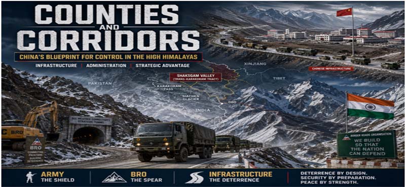
Why India Must Respond Through Infrastructure, Posture, and Deterrence by Design
A New County, An Old Strategy
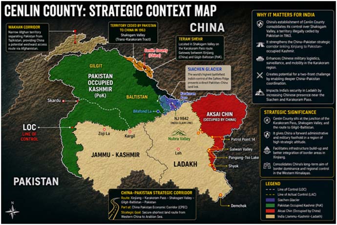
China’s creation of a new administrative county named Cenling in proximity to the Shaksgam Valley in April 2026 is not an isolated bureaucratic act. It is a calculated move in a long-term geopolitical playbook—one that fuses governance, infrastructure, and military preparedness into a single instrument of territorial consolidation.
This region, illegally ceded to China by Pakistan in 1963, has steadily transformed from a remote glacial wilderness into a strategically curated zone. What appears on paper as “administrative reorganization” is, in reality, the institutionalization of control—a shift from temporary presence to permanent ownership. The timing and location of this development are significant. The region lies close to one of the world’s most strategically sensitive military theatres, where the interests of China, Pakistan, and India intersect in a narrow but immensely consequential geography.
China understands a fundamental truth of modern geopolitics: Territory is not held by troops alone, but by roads, records, and residents.
The Historical Background: Why Shaksgam Matters
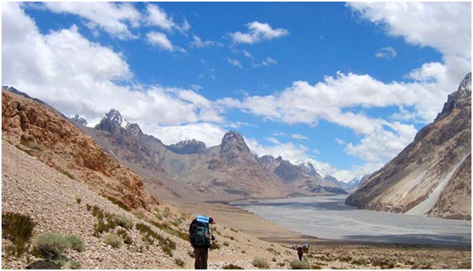
The Geography of Strategic Convergence. The Shaksgam Valley, also known as the Trans-Karakoram Tract, occupies a pivotal position in the Northern Himalayan arc. Though currently under Chinese control, the territory legally forms part of the erstwhile princely state of Jammu and Kashmir and is therefore claimed by India.
This harsh and sparsely populated region sits at the junction of some of Asia’s most critical strategic spaces. To its South lies the Siachen Glacier and Sub Sector North. To the West lies Pakistan-occupied territory connected to the Karakoram Highway. To the East and North lie China’s Xinjiang and Tibet regions. Geography gives Shaksgam significance far beyond its barren appearance.
The 1963 Sino-Pakistan Agreement. The roots of the present strategic challenge lie in the 1963 boundary agreement between China and Pakistan, under which Pakistan ceded approximately 5,180 square kilometres of territory in the Shaksgam region to China. India never recognized this agreement, maintaining consistently that Pakistan had no legal authority to transfer territory belonging to India.
This agreement laid the foundation for the long-term China–Pakistan strategic partnership that today manifests itself through military cooperation, infrastructure integration, and the China–Pakistan Economic Corridor. What was once a remote territorial adjustment has gradually evolved into a strategic axis with direct implications for India’s Northern security architecture.
The Strategic Importance of Siachen and Sub Sector North. India’s control over the Siachen Glacier has historically prevented direct territorial linkage between Chinese and Pakistani military positions in this sector. Siachen is therefore not merely a glacier defended for symbolic reasons. It is a strategic barrier preventing physical and operational convergence between two adversaries. Similarly, areas such as Daulat Beg Oldie and Sub Sector North act as critical buffers protecting India’s Northern flank. Any Chinese consolidation in the Shaksgam region must therefore be viewed through the prism of future strategic connectivity and military mobility.
Shaksgam is not peripheral geography. It is strategic connective tissue linking multiple theatres of power.
China’s Intent: Governance as a Weapon
The Chinese Frontier Model. China’s actions across its frontier regions reveal a consistent strategic pattern. It first asserts claims through maps and narratives. It then renames locations, creates administrative jurisdictions, establishes civilian infrastructure, develops roads and communications, and finally embeds military capability beneath the cover of governance. The creation of counties is central to this model. Administrative structures enable Beijing to project authority into remote regions while simultaneously building the legal and psychological basis for long-term control.
This is not temporary occupation. It is institutionalized consolidation.
Infrastructure and Sovereignty. China’s frontier doctrine rests heavily on infrastructure-led domination. Roads, tunnels, airstrips, surveillance systems, and communication networks are built not merely for economic purposes but to alter military geography permanently. The significance of county creation lies precisely here. Once an area receives administrative status, large-scale infrastructure development gains political legitimacy and bureaucratic momentum. Military logistics can then operate under civilian cover while the region gradually transforms into a permanently integrated frontier zone.
China does not separate governance from strategy. It combines the two into a single instrument of power projection.
The China–Pakistan Strategic Axis. The location of this county development also reflects Beijing’s larger strategic calculations regarding Pakistan. The region lies close to the corridors linking Xinjiang with Pakistan through the Karakoram system. Future infrastructure integration in this area could facilitate faster military coordination, alternative logistics routes, and deeper strategic cooperation between China and Pakistan in the Northern sector. Such developments would place additional pressure on India’s deployments in Ladakh and complicate India’s operational planning.
China’s long-term objective appears clear: create an interconnected frontier ecosystem where governance, mobility, and military capability reinforce one another continuously.
China does not merely occupy territory. It institutionalizes it.
Future Impact on India’s Security Matrix
The Tactical Impact. At the tactical level, expanded Chinese infrastructure and administrative consolidation will significantly improve the People’s Liberation Army’s ability to sustain troops, rotate deployments, and maintain permanent surveillance in extreme terrain. Roads reduce mobilization time dramatically. Logistics hubs enable year-round deployments. Communications infrastructure strengthens battlefield coordination. Surveillance systems improve situational awareness across difficult mountain sectors.
In high-altitude warfare, logistics often matter more than numbers. Infrastructure therefore becomes a force multiplier capable of altering the balance even without visible escalation.
The Operational Impact. Operationally, the consolidation of Chinese control near the Shaksgam region increases pressure on India’s Northern deployment architecture. Areas such as Sub Sector North and the approaches to Daulat Beg Oldie could face greater strategic vulnerability if Chinese mobility and logistics continue to improve faster than India’s infrastructure development. The possibility of coordinated pressure from both Chinese and Pakistani sides also becomes more credible over time.
The larger concern lies in the creation of integrated military corridors capable of supporting sustained operations across multiple axes simultaneously.
Infrastructure changes operational geometry.
The Strategic Impact. At the strategic level, the implications are even more serious. Administrative consolidation creates facts on the ground that gradually shape international perception and negotiation baselines. China’s approach seeks to transform disputed spaces into normalized governed territories over time. If left uncontested structurally, such measures could gradually weaken India’s long-standing territorial claims in practical terms.
The challenge is therefore not simply territorial. It is geopolitical and psychological.
In the Himalayas, roads are no longer support systems. They are strategic weapons.
India’s Graded Response: Deterrence by Design
India cannot afford to respond to structural Chinese expansion through episodic reactions alone. The challenge requires a long-term doctrine integrating military preparedness, infrastructure dominance, logistics resilience, and strategic signalling.
This doctrine may best be understood as “Deterrence by Design.”
From Defensive Posture to Deterrent Posture. Traditional deterrence relied heavily on troop presence and positional defence. Modern deterrence in the Himalayas depends increasingly on mobility, infrastructure depth, surveillance integration, and the ability to sustain forces rapidly across dispersed sectors.
India’s objective should not merely be to defend existing positions. It should be to create conditions under which any future Chinese expansion becomes operationally costly, strategically risky, and politically unattractive.
The Three Pillars of Deterrence by Design.
- The first pillar is tactical dominance through permanent terrain control and rapid reaction capability.
- The second pillar is operational mobility through roads, tunnels, alternate axes, and integrated logistics systems.
- The third pillar is strategic infrastructure development led by institutions capable of executing projects with speed, continuity, and national purpose.
Deterrence today is not built only by weapons deployed on the frontier. It is built by the capacity of the state to dominate geography through engineering, logistics, and sustained presence.
India’s answer to engineered encroachment must therefore be engineered deterrence.
Tactical Countermeasures: Dominating the Heights
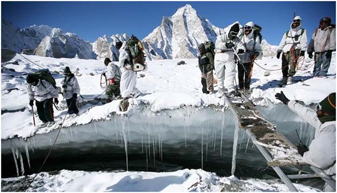
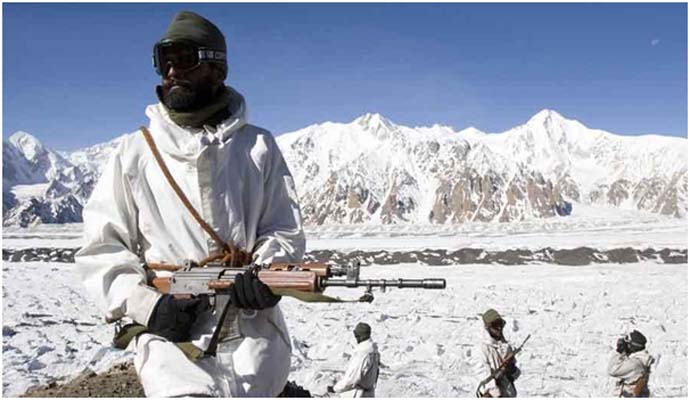
Permanent Control of the Key Terrain. India’s first objective must be to ensure that no tactical vacuum emerges across sensitive sectors adjoining the Northern frontier. In mountain warfare, tactical advantage is determined less by numbers and more by control of heights, observation dominance, and logistical endurance. The Indian Army must therefore continue transitioning from periodic presence to permanent positional dominance in strategically critical areas. Reinforced deployment on commanding heights overlooking key approaches from the Shaksgam side is essential to deny any possibility of surprise manoeuvre or creeping tactical ingress.
The continued strengthening of Indian positions in the Siachen sector remains central to this strategy. Siachen is not merely a battlefield frozen in time. It is a strategic barrier preventing the physical convergence of Chinese and Pakistani military spaces.
Integrated Surveillance and the Intelligence Grid. Future high-altitude conflict will depend heavily on information dominance. India must therefore establish a persistent surveillance architecture capable of monitoring infrastructure activity, troop movement, and logistical build-up across the Northern frontier in real time. This requires the integration of satellite reconnaissance, long-endurance drones, battlefield surveillance radars, electro-optical systems, and ground sensors into a unified intelligence grid.
The objective is not simply observation. It is anticipation.
China’s strategic advantage often lies in preparation and infrastructure readiness. India’s counter must lie in predictive awareness and rapid decision-making.
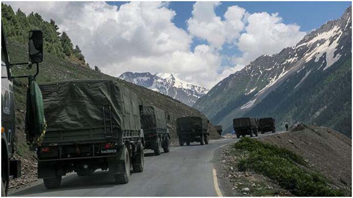
Rapid Reaction and Tactical Mobility. Tactical deterrence depends upon the ability to respond faster than the adversary can consolidate gains. This requires specialized rapid reaction forces capable of operating in extreme weather and difficult terrain without dependence on prolonged mobilization cycles. Air mobility through helicopters and advanced landing grounds remains important, but tactical mobility must increasingly be supported by reliable road infrastructure and forward logistics nodes.
The integration of troop mobility with road connectivity will determine how quickly India can reinforce threatened sectors.
Sustaining the Soldier at Extreme Altitude. High-altitude warfare is ultimately sustained by logistics. The soldier who survives the terrain dominates the battlefield. India must therefore continue investing in underground fuel storage, winter stocking systems, protected ammunition depots, specialized habitat infrastructure, and drone-assisted forward resupply mechanisms. Tactical resilience must be built into the terrain itself.
Terrain denied is escalation prevented.
Operational Countermeasures: BRO as the Spear of Deterrence
Infrastructure as Operational Power. The next phase of India’s Northern strategy must place infrastructure at the centre of operational planning. Roads, tunnels, bridges, and logistics corridors are no longer support assets operating behind the battlefield. They are now decisive components of combat capability. China’s advantage in the Himalayas has emerged not merely from troop deployment but from sustained infrastructure acceleration over decades. India’s response must therefore focus on achieving operational mobility that can neutralize this asymmetry.
This is where the Border Roads Organisation (BRO) assumes historic importance.
BRO Beyond Construction. The BRO can no longer be viewed as only an engineering agency responsible for road construction in difficult terrain. It has evolved into one of India’s most critical strategic institutions. Every road built in Ladakh shortens mobilization time. Every tunnel increases operational endurance. Every bridge expands military options.
BRO today represents India’s capacity to convert geography from vulnerability into deterrence.
Multi-Axis Connectivity and Redundancy. India’s existing vulnerability in several sectors arises from dependence on limited approach routes. A single disruption caused by weather, landslides, or hostile action can affect operational flexibility significantly. Future infrastructure planning must therefore prioritize multiple axes of connectivity. Strategic roads should not terminate into isolated corridors. They must form integrated networks capable of supporting alternate movement patterns during crises. The development of redundant bridges, alternate alignments, bypass routes, and lateral connectors is essential to reduce operational fragility.
The objective must be clear: no sector should depend upon a single logistical artery.
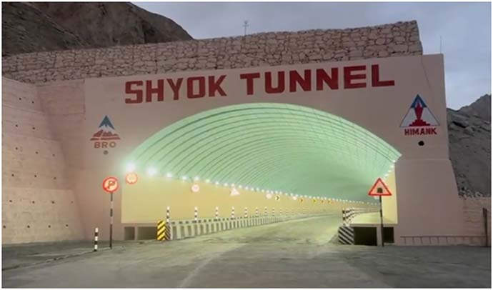
The Tunnel Doctrine. Seasonal isolation has historically constrained India’s military mobility in the Himalayas. This must change fundamentally. India needs an aggressive tunnel-building doctrine aimed at ensuring all-weather connectivity to critical frontier sectors. Tunnels reduce vulnerability to weather, avalanches, and surveillance while ensuring uninterrupted operational access throughout the year. The future balance in the Himalayas will depend not only on roads visible on the surface but also on protected infrastructure built beneath the mountains.
Every tunnel completed in Ladakh reduces China’s strategic advantage.
Technology, Speed, and Private Sector Integration. BRO’s future effectiveness will depend upon technological transformation and accelerated execution capability. Artificial intelligence-based terrain analysis, prefabricated construction systems, modular bridges, automated snow-clearance technologies, and high-altitude 3D printing can dramatically improve project timelines in difficult sectors. India must also integrate private infrastructure expertise into strategic construction through carefully structured partnerships while retaining military oversight and operational control.
The scale of the challenge requires national capacity, not departmental effort.
Integrated Air-Land Logistics. Operational resilience in the Himalayas requires the seamless integration of roads, tunnels, advanced landing grounds, heli-hubs, and logistics depots into a unified support architecture. Roads alone cannot sustain high-altitude deployments. Air assets alone cannot guarantee endurance. The future lies in integrated mobility systems capable of functioning even under degraded operational conditions. Infrastructure must therefore be planned not project by project, but theatre by theatre.
BRO is no longer merely building roads. It is engineering deterrence.
Strategic Measures: Countering Future Chinese Misadventures
Institutional Reform and National Coordination. India’s response to long-term Chinese expansion cannot remain fragmented across ministries and agencies. Border infrastructure and frontier management must become part of an integrated national security framework. A dedicated Northern Infrastructure Command integrating the Army, BRO, geospatial agencies, and strategic planners would significantly improve decision-making and project prioritization. Similarly, a non-lapsable strategic border infrastructure fund is essential to ensure continuity of execution independent of annual budgetary fluctuations.
Strategic infrastructure cannot operate on uncertain timelines.
Border Villages and Civilian Presence. China’s frontier strategy relies heavily on creating civilian ecosystems that reinforce sovereignty claims. India must respond through the accelerated development of model border villages equipped with communications, energy, healthcare, and economic infrastructure. A populated and connected frontier carries greater strategic resilience than an empty one.
Civilian presence, when integrated with infrastructure and security architecture, strengthens both legitimacy and logistics depth.
Diplomatic Assertion and Strategic Signalling. India must continue to assert clearly that the 1963 Sino-Pakistan boundary agreement remains illegal and unacceptable. Diplomatic consistency is essential to prevent the gradual normalization of altered realities. Strategic signalling must also become more visible. Infrastructure achievements, rapid mobilization capability, and border development initiatives should project confidence and preparedness both domestically and internationally.
The psychological dimension of deterrence matters as much as the physical one.
Geopolitical Balancing. China’s frontier strategy is supported by its broader geopolitical networks and economic corridors. India must therefore strengthen its own regional outreach through connectivity initiatives, strategic partnerships, and engagement with Central Asian states. The objective is not confrontation for its own sake. It is strategic balance. India must shape the wider environment in which Chinese expansion operates.
The future border will belong to the nation that can integrate geography, governance, and infrastructure faster than the other.
The Battle for the Himalayas Has Changed
The creation of a county near the Shaksgam region reflects a larger transformation underway across the Himalayan frontier. China is no longer relying solely on military posture to consolidate territorial advantage. It is redesigning the frontier itself through governance, infrastructure, mobility, and permanent institutional presence.
The contest in the Himalayas has therefore entered a new phase. Roads now influence sovereignty. Tunnels influence military endurance. Administrative structures influence geopolitical narratives. Infrastructure has become strategy by other means.
India’s response cannot remain reactive or episodic. It must be long-term, integrated, and structural. Tactical resilience, operational mobility, and strategic infrastructure development must work together as part of a coherent national doctrine.
This is the essence of Deterrence by Design.
The Indian Army will remain the shield safeguarding the frontier. But institutions such as the Border Roads Organisation must become the spear shaping the future battlefield before conflict ever emerges. The real contest in the Himalayas will not be decided solely by soldiers holding icy ridgelines. It will be decided by which nation can build faster, sustain longer, mobilize deeper, and dominate geography more effectively over time.
Counties and Corridors are no longer separate realities.
Together, they are the architecture of power in the high Himalayas.
ABOUT THE AUTHOR

Lt Gen Rajeev Chaudhry (Retd) is a social observer and writes on contemporary national and international issues, strategic implications of infrastructure development towards national power, geo-moral dimension of international relations and leadership nuances in changing social construct.