The Opening Signal — Assertion, Not Accommodation
The resumption of trade through Lipulekh Pass after a six-year pause is being read in some quarters as a routine administrative step. It is not. It is a calibrated assertion of India’s sovereign position in a region where ambiguity has increasingly been weaponised.
Nepal’s renewed objections to the use of Lipulekh must be viewed in context. For over two centuries, the alignment of the India–Nepal boundary in this sector has rested on a consistent interpretation of geography, administration, and treaty obligations. The sudden intensification of claims—particularly after 2020—does not reflect a discovery of new facts, but a reinterpretation driven by contemporary political and strategic considerations.
India’s decision to proceed with trade, despite objections, signals a refusal to allow long-settled arrangements to be unsettled through unilateral cartographic assertions. In the Himalayas, where terrain is unforgiving and logistics define control, presence is policy. Roads, routes, and regular activity are not symbolic—they are sovereign functions.
Lipulekh, therefore, is not merely a pass reopening to trade. It is a reaffirmation that continuity of administration and historical clarity cannot be displaced by recent, and arguably motivated, reinterpretations.
The Geography of Reality — Not of Convenience
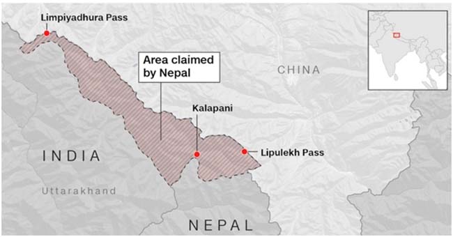
At the heart of the dispute lies a question that appears technical but is, in fact, foundational: where does the Kali (Mahakali) River originate? The answer determines the alignment of the boundary—and with it, the ownership of Kalapani, Lipulekh, and surrounding areas.
India’s position is rooted in geographic consistency and administrative practice. The river’s origin has long been identified in the vicinity of Kalapani, aligning with watershed principles and historical usage. This interpretation has not only been accepted in practice but has also underpinned governance, security deployment, and infrastructure development in the region for decades.
Nepal’s claim, which places the river’s origin at Limpiyadhura, significantly alters the boundary by shifting it Eastward. However, this interpretation raises critical questions. If the origin were indeed at Limpiyadhura, why did such a claim not manifest in a sustained or formal manner for nearly two centuries following the Treaty of Sugauli? Why did administrative and cartographic practices remain broadly aligned with India’s current position for decades?
Geography, particularly in the Himalayas, does not change. Rivers do not shift their sources over centuries. What changes is interpretation—and when such reinterpretation emerges abruptly, it invites scrutiny.
The issue, therefore, is not merely about competing claims. It is about whether long-established geographic understanding can be revised retrospectively without compelling new evidence. On this count, Nepal’s position appears less an organic evolution and more a strategic redefinition.
The Treaty of Sugauli — Continuity Versus Retrospective Revision
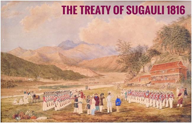
The Treaty of Sugauli, signed in 1816, forms the legal foundation of the India–Nepal boundary. It clearly designates the Kali River as the western boundary of Nepal. For over two centuries, this provision has been interpreted in a manner consistent with India’s present position.
What is crucial here is not just the text of the treaty, but its application over time. Boundaries are not sustained by documents alone; they are reinforced by administrative continuity, mutual understanding, and absence of sustained contestation. In this case, the alignment of the boundary near Kalapani has been reflected in governance patterns dating back to British India and continuing post-independence.
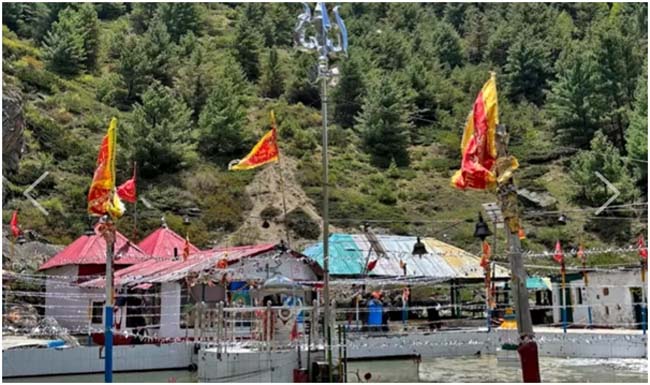
Significantly, this geographic understanding is also embedded in civilizational practice. Nestled in the Kalapani region, near what India identifies as the source of the Mahakali River, stands an ancient temple dedicated to Goddess Kali—an enduring marker of both geography and tradition. For decades, this shrine has drawn pilgrims from across the region, including devotees from both India and Nepal, who converge here to offer prayers at what is widely regarded as the river’s sacred origin. This uninterrupted pattern of worship reflects a long-standing, lived recognition of the river’s source, reinforcing the interpretation that has guided boundary alignment for generations.
Nepal’s recent assertion that the river originates at Limpiyadhura effectively seeks to reinterpret the treaty in a manner that was neither operationalized nor consistently asserted for generations. Such retrospective revision raises questions of both logic and intent.
If a boundary has functioned in a particular manner for over 200 years—without continuous, formal, and sustained objection—it acquires a degree of stability that cannot be easily unsettled. International boundary practice places significant weight on effective control and historical continuity. The sudden elevation of an alternative interpretation, therefore, is not merely a legal argument. It is a political act—one that attempts to reopen a settled understanding without corresponding historical continuity.
The Cartographic Turn — Assertion Through Maps
The release of Nepal’s revised political map in 2020 marked a decisive shift in the nature of the dispute. By formally incorporating Kalapani, Lipulekh, and Limpiyadhura within its territorial boundaries—and embedding this representation within its constitutional framework—Nepal transformed a previously manageable disagreement into a hardened position.
This move must be examined critically. Maps are not neutral instruments; they are assertions of intent. When deployed in this manner, they serve to formalize claims irrespective of ground realities or historical continuity.
India’s rejection of the revised map is grounded in precisely this concern. Unilateral cartographic assertion cannot substitute for negotiated settlement, particularly when it departs from long-standing administrative practice.
More importantly, the timing of this cartographic shift is telling. It coincided with heightened regional tensions, infrastructure development along sensitive borders, and increased external engagement in Nepal’s strategic space. This convergence suggests that the map was not merely a reflection of historical grievance, but part of a broader recalibration.
Cartography, in this context, becomes a tool of strategic signalling. It seeks to reshape narratives, influence domestic opinion, and alter the parameters of negotiation. Yet, maps alone do not establish control. They project intent—but must ultimately contend with facts on the ground.
In the Lipulekh sector, those facts remain anchored in continuity, presence, and long-established interpretation—factors that cannot be redrawn by lines on paper.
The China Factor — Engineering Friction Without Confrontation
Any serious assessment of the Lipulekh dispute must move beyond its bilateral framing and recognize the structural advantage it offers to China. While Beijing publicly maintains that the issue is a matter between India and Nepal, its strategic posture suggests a more calculated benefit derived from the situation.
Lipulekh sits at a sensitive tri-junction, opening directly into Tibet’s Ngari region. For China, this geography is not incidental. It is part of a wider frontier where infrastructure, mobility, and access are tightly interwoven with national security considerations. Stability in this region, from Beijing’s perspective, is best maintained not through clarity, but through managed ambiguity—particularly when such ambiguity complicates India’s strategic environment.
The pattern is familiar. Rather than direct confrontation, China often leverages peripheral pressures to stretch an adversary’s attention and resources. In this context, Nepal’s assertiveness—especially post-2020—creates precisely the kind of secondary friction that serves Chinese interests without necessitating overt involvement.
This does not imply that Nepal acts at the behest of China. However, it does suggest that Beijing’s expanding economic and strategic engagement with Kathmandu has created conditions in which such positions are more likely to emerge and be sustained.
The result is a subtle but effective dynamic: India faces a layered challenge in a sensitive region, while China maintains formal distance. In the Himalayas, where overt escalation carries high risks, such indirect leverage is often more valuable than direct confrontation.
2020 — Infrastructure Meets Opportunistic Assertion
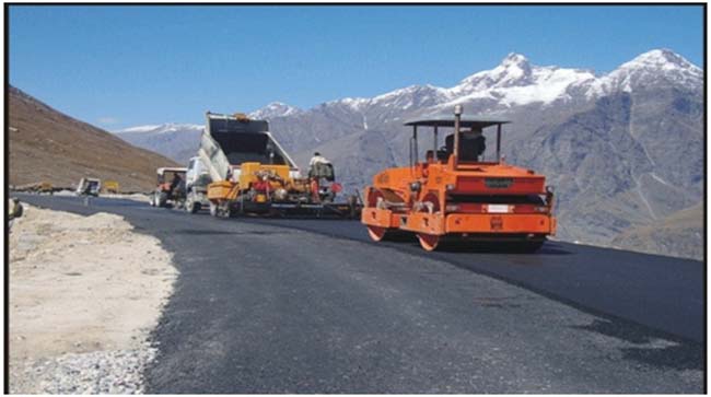
The events of 2020 marked a decisive shift in the trajectory of the Lipulekh issue. India completed formation cutting on the Dharchula–Lipulekh road as a logical step in strengthening connectivity to a remote but strategically vital region. It addressed longstanding logistical constraints and enhanced access for both civilian and strategic purposes.
However, the reaction from Nepal was immediate and disproportionate. The road was portrayed not as infrastructure within an established administrative framework, but as an encroachment. This narrative rapidly escalated into formal diplomatic protest and culminated in the release of a revised political map.
The sequence of events raises an important question: why did a project within a long-administered area suddenly trigger such a sharp response? The answer lies less in geography and more in timing and context.
India’s broader push to upgrade border infrastructure—particularly after heightened tensions with China—signalled a shift toward greater operational readiness in the Himalayas. In such a scenario, contesting India’s position in adjacent sectors becomes a way of complicating that shift.
Nepal’s response, therefore, appears less as a spontaneous assertion of historical grievance and more as an opportunistic repositioning aligned with a changing strategic environment. The infrastructure did not create the dispute; it exposed and accelerated its politicization.
In geopolitics, moments of transition often invite contestation. The year 2020 was one such moment—and Lipulekh became one of its focal points.
Nepal’s Posture — Assertion, Politics, and Strategic Overreach
Nepal’s position in the Lipulekh dispute reflects a complex mix of domestic politics, national identity, and external balancing. However, in recent years, this posture has exhibited elements of overreach that risk undermining its own strategic stability.
The elevation of the Kalapani issue into a central political theme within Nepal has been driven in part by internal dynamics. Territorial assertion offers a powerful unifying narrative, particularly in periods of political competition. By foregrounding sovereignty, political actors can consolidate domestic support.
Yet, such positioning comes with risks. When claims are formalized without corresponding control or sustained historical assertion, they create expectations that are difficult to translate into outcomes. The gap between assertion and capability becomes a source of vulnerability.
At the same time, Nepal’s increasing engagement with China provides it with an alternative strategic axis. This has emboldened sections of its leadership to adopt positions that might earlier have been moderated by geographic and economic realities.
However, geography remains constant. India continues to be Nepal’s primary economic partner, transit route, and immediate neighbour in a deeply interconnected relationship. Any attempt to recalibrate this equation through assertive territorial claims must contend with these structural realities.
Nepal, therefore, finds itself navigating a delicate balance. In seeking to assert autonomy, it risks stretching its strategic bandwidth. The Lipulekh issue, in this sense, reflects not just assertion—but the limits of that assertion.
The 2026 Reopening — Continuity as Strategy
The resumption of trade through Lipulekh in 2026 must be understood as a deliberate act of strategic continuity. By restoring activity along this route, India has effectively reinforced its long-standing administrative and operational presence in the region.
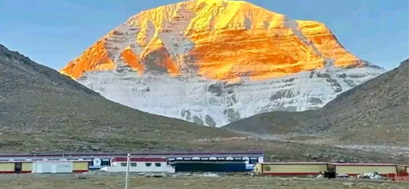
Set along the approach to Lipulekh stands the striking Om Parbat, where nature itself appears to inscribe a sacred symbol upon the mountain face. Visible to pilgrims and travellers moving along this corridor, the peak has long served as both a spiritual waypoint and a geographic marker in this high Himalayan landscape. Its presence reinforces the civilizational continuity of this route—one that has connected faith, movement, and memory across generations.
In this context, the reopening of Lipulekh is not merely about trade. It is about restoring access along a corridor where geography and heritage converge. The enduring presence of Om Parbat overlooking this passage is a reminder that these routes were never transient; they are part of a deeper continuum that predates modern contestation.

Nepal’s objections, while consistent with its stated position, have not translated into escalation. This reflects an implicit recognition of the limits of contestation in the absence of corresponding leverage.
For India, the reopening serves multiple purposes. It restores a traditional trade corridor, facilitates pilgrimage, and strengthens logistical capability. More importantly, it signals that unilateral cartographic assertions will not alter ground realities.
The broader message is clear: sovereignty is not exercised episodically, but sustained through consistent presence and activity. In this framework, trade becomes more than commerce—it becomes a mechanism of strategic reinforcement.
Reasserting Logic in the Himalayan Equation

The Lipulekh dispute ultimately brings into focus a fundamental question: can long-established boundaries, grounded in treaty interpretation, administrative continuity, and geographic logic, be redefined through recent reinterpretation and cartographic assertion?
India’s position rests on a coherent foundation. The Treaty of Sugauli established the Kali River as the boundary. Its interpretation, aligned with the river’s origin near Kalapani, has been reflected in governance and practice for over two centuries. This continuity is not incidental—it is the basis of stability.
Nepal’s recent claim, centred on relocating the river’s origin to Limpiyadhura, represents a departure from this continuity. In the absence of sustained historical assertion or new compelling evidence, such a shift appears less a correction and more a recalibration driven by contemporary considerations.
Compounding this dynamic is the broader strategic environment, where external influence—particularly from China—introduces additional complexity. While not overt, this influence shapes incentives and amplifies contestation.
In this context, India’s approach has been measured but firm. By maintaining presence, advancing infrastructure, and restoring activity at Lipulekh, it reinforces the principle that sovereignty cannot be diluted by delayed reinterpretation.
The Himalayas do not lend themselves to easy resolution. But they do demand clarity of logic. In the contest of maps, mountains, and manoeuvring, it is this clarity—grounded in history, geography, and continuity—that ultimately sustains legitimacy.
And at Lipulekh, that clarity remains decisively on India’s side.
ABOUT THE AUTHOR

Lt Gen Rajeev Chaudhry (Retd) is a social observer and writes on contemporary national and international issues, strategic implications of infrastructure development towards national power, geo-moral dimension of international relations and leadership nuances in changing social construct.


