Exploring the Potential of Joint Indo-China friendship in the great adventure trail
Do we have the key to the Karakoram in particular? When the dragon-elephant tango sweeps the floor, wouldn’t the most precious metal don that disruptor mantle? The answer is ‘Of course’ and behold! From our all-important tourism asset standpoint, could the Karakoram factor have gained significance, affirmed by Xi, “India and China are good neighbours, friends and partners…”. Handled deftly, for starters, could this enable India-China “Joint, Friendly, Exploration” on both sides of the LAC. Nevertheless, the terrain remains desperately competitive, needing sharp post-COVID foci on the back-end (product) and front-end (market).
Even so, the tourism sector’s resilient global potential is evident especially in the Karakoram where, tourism receipts and arrivals apart, the negative impacts of over-tourism remain cognizant.
Hence, as the Budget explicitly avers, the tourism sector should now install top-end technical arrangements to replace ‘pledges’ (basically bland expressions of pious intent) by scientific, monitorable, climate-resilient governance indices, using cross-sector technical expertise, best practice, base-lining and EIA for Work Plan Formulation, Access to Multilateral Funding, Implementation, Monitoring and Evaluation.
To formalize the way forward, an empowered body needs to unlock India’s full tourism potential, despite extensive tourism-friendly legislation starting with the Sarai Act, Indian Forest Act of 1927 and the Tourism Ministry’s comprehensive Sustainable Tourism Criteria for India (STCI) etc.
Development of international standard, sustainable trekking and nature routes across India, including mountain trails in Himachal Pradesh, Uttarakhand and Jammu & Kashmir, hence also the Karakoram, and in Araku Valley (Eastern Ghats), Podhigai Malai (Western Ghats), besides birdwatching around Pulikat Lake, each compositely focused on heightened sustainability, conservation and livelihoods, each geared to responsible tourism.
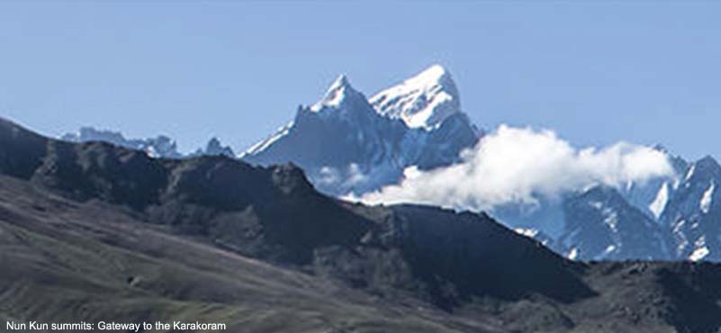
Not left behind, apart from mountaineering targets among the beauteous Apsaras, Saser Kangri, Teram Kangri summits et al in the Karakoram, there lies the alluring transborder Shaksgam-Shyok watershed, looping in with viewership options over Chushul, Depsang and Changtang Advance Landing Grounds on the route to Hanle, foundational gompa where Buddhism arrived in Ladakh, nurtured by the venerable Sengge Namgyal.
 Stitching into the classic glacial giants of the Karakoram, namely Teram Shahr, Rimo, Lilafond and Bilafond, themselves patterned systemically in the vast recesses of the Siachen glacier itself, all the way to its basin head at Indira Col, re-aligning perhaps one day with Concordia, the Baltoro Glacier and K2. Earlier on, that broad sweep enmeshed with Central Asian trade arteries was among the passages for the advent of Islam.
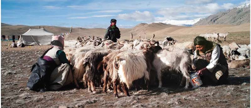
The Thoise airstrip for commercial fixed wing and heli-sorties, attractive homestays nearby, takes a five-hour drive across the Khardung La from Leh, providing virtually limitless choices for sustainable, locally inclusive, livelihoods-oriented itineraries. Besides, there is add-on advantage via gender equity, MSMEs, employable youth and destination management. Among the earliest iconic Karakoram visuals is Sepoy Sonam Norfel of 7 J&K Militia with two ponies and *Trishul. The wind sock was made of Lt MM Kumar’s bedsheet as the Chushul airfield lacked one, c.1959.

Eric Shipton, the legendary British explorer, leading The Imperial College Karakoram Expedition, had suggested this route, as reported in the prestigious Alpine Journal, 1957.
“Though the only large unexplored areas of the Karakoram lie to the north of the main watershed and are politically difficult of access, there is still some minor exploration to be done on the southern side, and there is plenty of scope here for original scientific work. The region of the Siachen glacier is particularly interesting in both respects. With the possible exception of the Fedchenko glacier in the Russian Pamirs, the Siachen is the largest glacier in Asia, its basin covering an area of some 800 square miles. Though its main features had been well mapped by Peterkin of the Workman expedition of 1912, there were several unknown areas on its periphery, while many of its geographical and geological features are peculiar.
 With Skardu now accessible by air in a few days from London we hoped to be able to cross the Bilafond La by mid-July and to spend eight weeks working from a base at the junction of the Siachen and Lolofond glaciers. From here, dividing the party into two sections, we planned to make a series of journeys of a fortnight each. During the first fortnight one section would map the heads of the Lolofond and K36 glaciers while the other would visit the head of the Siachen, look for a possible pass to the Baltoro, and attempt to cross either of the two cols visited by the Workmans, the Indira Col and the Turkestan La, towards the Shaksgam.”
The second fortnight would be spent in an exploration of the upper Terim Shah glacier, the chief tributary of the Siachen, and in an attempt to find a way across the Apsaras group to the upper Shaksgam. We thought that, if weather and conditions were good, we might devote the third period to a brief attempt to climb Saltoro Kangri (25,400 ft.), which would have already been reconnoitred from the K36 glacier. The peak had been attempted by John Hunt and others in 1935.1 For the final fortnight it was proposed to move the whole party to the head of the Siachen, whence one section would attempt the crossing to the Baltoro while the other would cross the Sia La and try to disentangle the topographical muddle (which then existed) to the west of that pass”.
Adding tremendous topographical and morphological value to this unique setting in the Karakoram, far away to its east is “the basin of the Yarlung Tsangpo-Brahmaputra… ” consisting of “a mosaic of five different zones”, vividly captured in the recent study The Restless River.
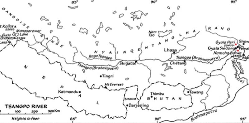
In order to appreciate the full tourism potential of these new India-China arrangements, ideally two groups should be programmed for departure, trekking across the Niti/Barahoti Pass to Manasarovar where they will bifurcate:
- One group turning west along the Rakshas Tal/Sutlej axis in the shadow of the Karakoram and Indus towards Rudok, the Lop Nor marshes and the Shaksgam-Shyok watershed to attain the Yarkand passage for the Karakoram Pass and India (ideally Chinese permission will be obtained for our India-China friendly visit);
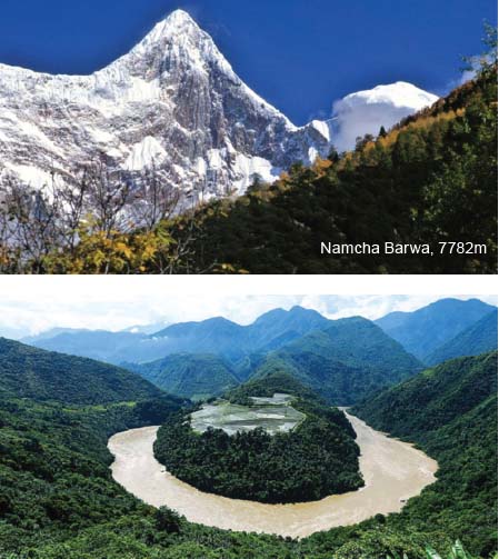
- Second group turning eastward covering the basin of the Yarlung Tsangpo river north of the Himalaya in the Tibetan plateau, then deflected south through the world’s deepest gorge and Great Bend, dominated by the mammoth Namcha Barwa (7782m) and Gyala Peri (7294m) peaks 22km apart, becoming the Brahmaputra river in India, followed by a Tibet-India crossover (for this too, ideally Chinese permission will be obtained for our India-China friendly visit).
- Keeping options open, the two expeditions could retrace their steps and rejoin at Manasarovar, include Lhasa visit, to take the Barahoti-Niti Pass trek back to Dehra Dun, via Malari.

BROAD MOVEMENT DIRECTION:
- Common for both routes till Arrival at Manasarovar (Ex Dehra Dun), Day 7-8.
- Onward for Yarlung Tsangpo route: Arrival Bayizhen (via Lhasa), Day 11.
- Arrival Yarlung Tsangpo river, Day 14.
- Arrival/Meet Chief officer of Mainling Xian, Day 16.
- Arrival Pe and cross Yarlung Tsangpo, Day 17-18.
- Arrival/Camp at Chube, last Tibetan village, on left bank of Yarlung Tsangpo, Day 19-20.
- Walk six hours to Gyala gompa, opposite Gyala village, essential pilgrimage site, Day 20.
Pradesh. Dorje narrates local lore
Gyala Peri, next to Rakaposhi in the Karakoram, is the world’s largest abyss climb with vertical walls reaching the banks of the Yarlung Tsangpo, north of its Big Bend and NNW of Namcha Barwa (7782m) on the eastern edge of the Himalaya, its four ridges converging at the summit, 6400m above notable forest along the Yarlung Tsangpo which creates an arc around the peak, becoming the Brahmaputra.
Gelling, is the first Indian village on the Indo-Tibetan border (25km from Tuting), abuts the Siang River, onward from the deflected Yarlung Tsangpo through the world’s deepest gorge.
Tourism choices, Master Plan based, could thus transform infinitely in the Karakoram-Himalaya, still open to querulous tilting at source windmills of the four greats that penetrate the range namely, Indus, Satluj, Karnali and YarlungTsangpo/Brahmaputra… steadfast witnesses to the Central Asian Trade Route, the Silk Road and Great Game… now resurrected as the Belt-Road initiative.
ABOUT THE AUTHOR

Sudhir Sahi is a Delhi-based UN Tourism and environment specialist. Formerly with Air India, he has been associated with Indian Mountaineering Foundation, authored research papers on environment and tourism.